
Thank you for supporting this site ❤️
Make a donation
Make a donation
Walde topographic map
Click on the map to display elevation.
Thank you for supporting this site ❤️
Make a donation
Make a donation
About this map
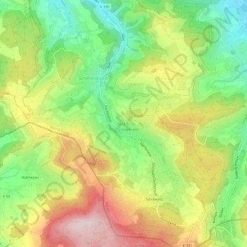
Name: Walde topographic map, elevation, terrain.
Location: Walde, Schmiedrued, Bezirk Kulm, Aargau, 5046, Schweiz (47.24264 8.09070 47.28264 8.13070)
Average elevation: 664 m
Minimum elevation: 505 m
Maximum elevation: 853 m
Thank you for supporting this site ❤️
Make a donation
Make a donation
Other topographic maps
Click on a map to view its topography, its elevation and its terrain.
Dürrenäsch
Schweiz > Aargau > Bezirk Kulm
Das Dorf besitzt eine lockere Siedlungsstruktur mit einigen auseinander liegenden Häusergruppen, die stellenweise mit dem kleinen Zentrum zusammengewachsen sind. Es liegt in einem Sattel des Höhenzugs, der das Wynental vom Seetal trennt. Der weitaus grössere Teil des Gemeindegebiets wird gegen Westen in…
Average elevation: 594 m
Thank you for supporting this site ❤️
Make a donation
Make a donation