
Thank you for supporting this site ❤️
Make a donation
Make a donation
Hawk Pride Mountain topographic map
Click on the map to display elevation.
Thank you for supporting this site ❤️
Make a donation
Make a donation
Hawk Pride Mountain
Hawk Pride Mountain is a summit in Colbert County, Alabama, in the United States. With an elevation of 820 feet (250 m), is the 489th highest summit in the state of Alabama.
Thank you for supporting this site ❤️
Make a donation
Make a donation
About this map
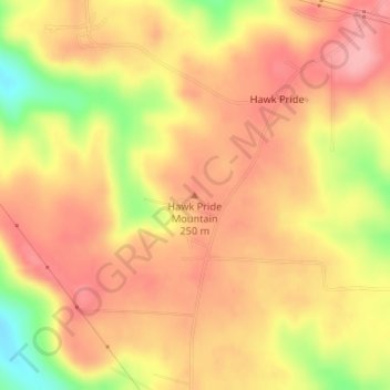
Name: Hawk Pride Mountain topographic map, elevation, terrain.
Average elevation: 231 m
Minimum elevation: 155 m
Maximum elevation: 271 m
Thank you for supporting this site ❤️
Make a donation
Make a donation
Other topographic maps
Click on a map to view its topography, its elevation and its terrain.