
Clarendon Parish topographic map
Interactive map
Click on the map to display elevation.
About this map
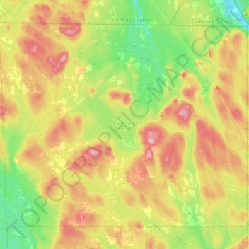
Name: Clarendon Parish topographic map, elevation, terrain.
Location: Clarendon Parish, Charlotte County, New Brunswick, Canada (45.31269 -66.78816 45.50184 -66.45944)
Average elevation: 160 m
Minimum elevation: 34 m
Maximum elevation: 335 m
Other topographic maps
Click on a map to view its topography, its elevation and its terrain.
Storeytown
Canada > New Brunswick > Blissfield Parish > Doaktown
Storeytown, Doaktown, Blissfield Parish, Northumberland County, New Brunswick, E9C 1G7, Canada
Average elevation: 83 m
Moncton
Canada > New Brunswick > Moncton
Moncton, Moncton Parish, Westmorland County, New Brunswick, Canada
Average elevation: 52 m
Fundy National Park of Canada
Fundy National Park of Canada, 114, Albert County, New Brunswick, E4H 1N5, Canada
Average elevation: 230 m