
Thank you for supporting this site ❤️
Make a donation
Make a donation
Magog topographic map
Click on the map to display elevation.
Thank you for supporting this site ❤️
Make a donation
Make a donation
About this map
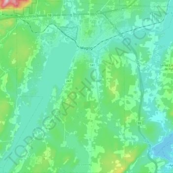
Name: Magog topographic map, elevation, terrain.
Location: Magog, Memphrémagog, Quebec, Canada (45.16080 -72.24729 45.30571 -72.04219)
Average elevation: 250 m
Minimum elevation: 159 m
Maximum elevation: 674 m
Thank you for supporting this site ❤️
Make a donation
Make a donation
Other topographic maps
Click on a map to view its topography, its elevation and its terrain.
Scouts Canada - Lake Lovering Scouts Reserve
Canada > Quebec > Memphrémagog > Magog
Average elevation: 260 m
Thank you for supporting this site ❤️
Make a donation
Make a donation
Thank you for supporting this site ❤️
Make a donation
Make a donation