Geolocate

Tobol River topographic map

Interactive map

Click on the map to display elevation.

About this map

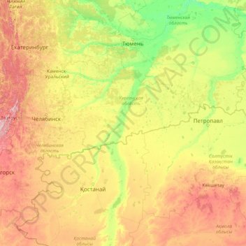
Name: Tobol River topographic map, elevation, terrain.

Location: Tobol River, Ural Federal District, 640008, Russia (51.40723 61.00818 58.15525 68.21730)

Average elevation: 200 m

Minimum elevation: 35 m

Maximum elevation: 1,068 m

Other topographic maps

Click on a map to view its topography, its elevation and its terrain.

Ob River

Russia

The combined Ob-Irtysh system, the fourth-longest river system of Asia (after Yenisei, and China's Yangzi and Yellow rivers), is 5,410 kilometres (3,360 mi) long, and the area of its basin 2,990,000 square kilometres (1,150,000 sq mi). The river basin of the Ob consists mostly of steppe, taiga, swamps, tundra,…

Average elevation: 122 m

Novoselye

Russia > Leningrad oblast > Kaarosta District

Average elevation: 23 m

Omsk

Russia > Omsk Oblast

Omsk is in the south of the West Siberian Plain, along the banks of the north-flowing Irtysh, at its confluence with the Om River. The city has an elevation of 87 meters (285 ft) above mean sea level at its highest point.

Average elevation: 107 m

Buryatia

Russia

Average elevation: 923 m

Sysert

Russia > Sverdlovsk Oblast > Sysertsky District

Average elevation: 254 m

Abakan

Russia > Republic of Khakassia

Average elevation: 267 m

Нарын

Russia > Buryatia > Zaigrayevsky Rayon > Нарын

Average elevation: 748 m

Astrakhan

Russia > Astrakhan Oblast > Astrakhan

Astrakhan (Russian: Астрахань, tr. Astrakhan', IPA: ; Tatar: Cyrillic Әстерхан, Latin Ästerxan) is the largest city and administrative centre of Astrakhan Oblast in Southern Russia. The city lies on two banks of the Volga, in the upper part of the Volga Delta, on eleven islands of the Caspian…

Average elevation: -21 m

Troitsk

Russia > Chelyabinsk Oblast > Troitsk District > Troitsk

Average elevation: 187 m

Satka

Russia > Chelyabinsk Oblast > Satkinsky District > Satka

Average elevation: 471 m

Sim

Russia > Chelyabinsk Oblast > Ashinsky District > Sim

Average elevation: 319 m

Minyar

Russia > Chelyabinsk Oblast > Ashinsky District > Minyar

Average elevation: 288 m

Lena River

Russia > Sakha Republic

Average elevation: 252 m

Beryozovy

Russia > Krasnodar Krai > Beryozovy

Average elevation: 32 m

Solnechnyy

Russia > Khabarovsk Krai > Solnechnyy

Average elevation: 391 m

Солнечный

Russia > Orenburg Oblast

Average elevation: 103 m

Kolyvan

Russia > Novosibirsk Oblast > Kolyvan

Average elevation: 119 m

Okha

Russia > Sakhalin Oblast > Okha

Average elevation: 26 m

Belogorsk

Russia > Amur Oblast > Belogorsk

Average elevation: 171 m

Primorsky Krai

Russia > Primorsky Krai

Highlands dominate the territory of the krai. Most of the territory is mountainous, and almost 80% of it is forested. The average elevation is about 500 meters (1,600 ft). Sikhote-Alin is a mountainous formation, extending for the most part of the Krai. It consists of a number of parallel ranges: the…

Average elevation: 255 m

Khatanga

Russia > Krasnoyarsk Krai > Khatanga

Average elevation: 11 m

Kamchatka Krai

Russia > Kamchatka Krai

Average elevation: 224 m

Uy River

Russia > Omsk Oblast

Average elevation: 118 m

Khabarovsk Krai

Russia > Khabarovsk Krai

Average elevation: 478 m

Moscow

Russia > Moscow

Moscow is situated on the banks of the Moskva River, which flows for just over 500 km (311 mi) through the East European Plain in central Russia. 49 bridges span the river and its canals within the city's limits. The elevation of Moscow at the All-Russia Exhibition Center (VVC), where the leading Moscow…

Average elevation: 177 m

Kabardino-Balkaria

Russia > Kabardino-Balkaria

Average elevation: 704 m

Krasnodar

Russia > Krasnodar Krai > Krasnodar

Average elevation: 28 m

Mariinskoye

Russia > Khabarovsk Krai > Mariinskoye

Average elevation: 10 m

Ukhta

Russia > Komi Republic > Ukhta

Average elevation: 105 m