
Make a donation
Ward Hill topographic map
Click on the map to display elevation.
Make a donation
About this map
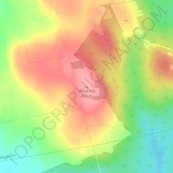
Name: Ward Hill topographic map, elevation, terrain.
Location: Ward Hill, Maine, 04950, United States (44.78696 -69.81455 44.78706 -69.81445)
Average elevation: 160 m
Minimum elevation: 107 m
Maximum elevation: 204 m
Make a donation
Other topographic maps
Click on a map to view its topography, its elevation and its terrain.
Make a donation
Aroostook County
According to the U.S. Census Bureau, the county has a total area of 6,828 square miles (17,680 km2), of which 6,671 square miles (17,280 km2) is land and 156 square miles (400 km2) (2.3%) is water. Aroostook County is Maine's largest county by area, about the size of Connecticut and Rhode Island combined. The…
Average elevation: 274 m
Make a donation
Scarborough
United States > Maine > Cumberland County
According to the United States Census Bureau, the town has a total area of 70.63 square miles (182.93 km2), of which, 47.61 square miles (123.31 km2) is land and 23.02 square miles (59.62 km2) is water. Drained by the Scarborough River, Nonesuch River, Libby River and Spurwink River, the town is situated…
Average elevation: 17 m
Make a donation
Franklin County
According to the U.S. Census Bureau, the county has a total area of 1,743 square miles (4,510 km2), of which 1,697 square miles (4,400 km2) is land and 47 square miles (120 km2) (2.7%) is water. The county is crossed by some of the northernmost parts of the Appalachian Mountain range, with the terrain also…
Average elevation: 428 m
Knox County
At an elevation of 1,381 feet above sea level, Mount Megunticook, located in Camden Hills State Park, is the highest point in the county. It ranks 10th in elevation out of Maine's 16 county high points. It is a popular hiking destination in the region.
Average elevation: 29 m
Camden
United States > Maine > Knox County
According to the U.S. Census Bureau, the town has a total area of 26.65 square miles (69.02 km2), of which, 18.24 square miles (47.24 km2) of it is land and 8.41 square miles (21.78 km2) is water. Drained by the Megunticook River, Camden is located beside Penobscot Bay and the Gulf of Maine, part of the…
Average elevation: 63 m
Make a donation
Acadia National Park
United States > Maine > Hancock County > Bar Harbor
The ecological zones at Acadia National Park, from highest to lowest elevation, include: nearly barren mountain summits; northern boreal and eastern deciduous forests on the mountainsides; freshwater lakes and ponds, as well as wetlands like marshes and swamps in the valleys between mountains; and the Atlantic…
Average elevation: 9 m
Wells
United States > Maine > York County
According to the United States Census Bureau, the town has a total area of 73.61 square miles (190.65 km2), of which, 57.55 square miles (149.05 km2) of it is land and 16.06 square miles (41.60 km2) is water. Wells is drained by the Webhannet River. The highest point in town is an unnamed hill located a half…
Average elevation: 28 m
Make a donation
Baxter State Park
United States > Maine > Piscataquis County
After assuming the Maine Senate presidency during the state's 80th legislative session, Percival Baxter appointed his brother Rupert, a Senator from Sagadahoc County, to the Committee on State Lands and Forest Preservation, which would be considering legislation that would create a state park at Katahdin.…
Average elevation: 377 m
Make a donation
Make a donation
Make a donation
Make a donation
Cliff Island
United States > Maine > Cumberland County > Portland > Cliff Island
Average elevation: 1 m
Make a donation
No Name Pond
United States > Maine > Somerset County > Bald Mountain Township T4 R3
Average elevation: 686 m
Make a donation
South Berwick
United States > Maine > York County
According to the United States Census Bureau, the town has a total area of 32.64 square miles (84.54 km2), of which 32.13 square miles (83.22 km2) is land and 0.51 square miles (1.32 km2) water. Located beside the New Hampshire border, South Berwick is drained by the Great Works River and Salmon Falls River.…
Average elevation: 46 m
Make a donation
Make a donation
Sturtevant Pond
United States > Maine > Oxford County > Magalloway Plantation
Average elevation: 406 m
Make a donation
Make a donation
Make a donation
Make a donation
Aroostook County
According to the U.S. Census Bureau, the county has a total area of 6,828 square miles (17,680 km2), of which 6,671 square miles (17,280 km2) is land and 156 square miles (400 km2) (2.3%) is water. Aroostook County is Maine's largest county by area, about the size of Connecticut and Rhode Island combined. The…
Average elevation: 274 m
Make a donation
Make a donation
Make a donation
Make a donation
Aroostook County
According to the U.S. Census Bureau, the county has a total area of 6,828 square miles (17,680 km2), of which 6,671 square miles (17,280 km2) is land and 156 square miles (400 km2) (2.3%) is water. Aroostook County is Maine's largest county by area, about the size of Connecticut and Rhode Island combined. The…
Average elevation: 274 m
Franklin County
According to the U.S. Census Bureau, the county has a total area of 1,743 square miles (4,510 km2), of which 1,697 square miles (4,400 km2) is land and 47 square miles (120 km2) (2.7%) is water. The county is crossed by some of the northernmost parts of the Appalachian Mountain range, with the terrain also…
Average elevation: 428 m
Make a donation
Make a donation
Make a donation
Make a donation