
Make a donation
Golan Heights topographic map
Click on the map to display elevation.
Make a donation
Golan Heights
The plateau that Israel controls is part of a larger area of volcanic basalt fields stretching north and east that were created in the series of volcanic eruptions that began recently in geological terms, almost 4 million years ago. The rock forming the mountainous area in the northern Golan Heights, descending from Mount Hermon, differs geologically from the volcanic rocks of the plateau and has a different physiography. The mountains are characterised by lighter-colored, Jurassic-age limestone of sedimentary origin. Locally, the limestone is broken by faults and solution channels to form a karst-like topography in which springs are common.
Make a donation
About this map
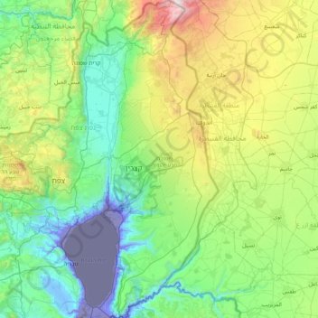
Name: Golan Heights topographic map, elevation, terrain.
Location: Golan Heights, North District, Israel (32.68213 35.61332 33.33563 35.89502)
Average elevation: 524 m
Minimum elevation: -222 m
Maximum elevation: 2,351 m
Make a donation
Other topographic maps
Click on a map to view its topography, its elevation and its terrain.
Majdal Shams
The name Majdal Shams is of Aramaic origin, meaning: "tower of sun," possibly in reference to the town's elevation. Another hypothesis suggests that the town was originally called Majdal al-Sham (Majdal of Damascus) to distinguish it from the towns of al-Majdal on the Mediterranean coast and al-Majdal on the…
Average elevation: 1,184 m