
Make a donation
Majdal Shams topographic map
Click on the map to display elevation.
Make a donation
Majdal Shams
The name Majdal Shams is of Aramaic origin, meaning: "tower of sun," possibly in reference to the town's elevation. Another hypothesis suggests that the town was originally called Majdal al-Sham (Majdal of Damascus) to distinguish it from the towns of al-Majdal on the Mediterranean coast and al-Majdal on the Sea of Galilee.
Make a donation
About this map
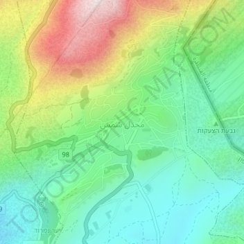
Name: Majdal Shams topographic map, elevation, terrain.
Location: Majdal Shams, Golan Subdistrict, North District, Israel (33.25894 35.75916 33.27811 35.77780)
Average elevation: 1,184 m
Minimum elevation: 963 m
Maximum elevation: 1,610 m
Make a donation
Other topographic maps
Click on a map to view its topography, its elevation and its terrain.
Nazareth
As of the early 1990s, no city plans drafted by Nazareth Municipality have been approved by the government (both the British Mandate and later Israel) since 1942. This has left many people in Nazareth who vote in the city's municipal elections and receive services from its municipality effectively outside of…
Average elevation: 322 m
Golan Heights
The plateau that Israel controls is part of a larger area of volcanic basalt fields stretching north and east that were created in the series of volcanic eruptions that began recently in geological terms, almost 4 million years ago. The rock forming the mountainous area in the northern Golan Heights,…
Average elevation: 524 m