
Make a donation
Asheville topographic map
Click on the map to display elevation.
Make a donation
Asheville
Asheville, located in Buncombe County, North Carolina, is characterized by a diverse and picturesque topography primarily shaped by its position within the Blue Ridge Mountains. The city itself sits at an elevation of approximately 2,200 feet, surrounded by peaks that rise significantly higher, such as Mount Mitchell, which towers at 6,684 feet, making it the highest point east of the Mississippi River. The terrain features a mix of rolling hills and steep slopes, interspersed with lush valleys and dense forests, offering a rich variety of flora and fauna. The nearby French Broad River winds through the area, adding to the scenic beauty and contributing to the region's recreational opportunities, including hiking and river activities. This mountainous landscape not only enhances Asheville's natural charm but also plays a significant role in its climate, providing cooler temperatures and distinct seasonal variations.
Make a donation
About this map
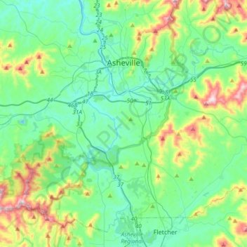
Name: Asheville topographic map, elevation, terrain.
Location: Asheville, Buncombe County, North Carolina, United States (35.41646 -82.67036 35.65608 -82.46047)
Average elevation: 727 m
Minimum elevation: 578 m
Maximum elevation: 1,209 m
Make a donation
Other topographic maps
Click on a map to view its topography, its elevation and its terrain.
Arden
United States > North Carolina > Buncombe County > Asheville > Royal Pines
Average elevation: 693 m
Haw Creek Park
United States > North Carolina > Buncombe County > Asheville > Dogwood Grove
Average elevation: 666 m
Make a donation
Make a donation
Biltmore Village
United States > North Carolina > Buncombe County > Asheville
Average elevation: 642 m
Make a donation
Make a donation
Make a donation
Make a donation
Royal Pines
United States > North Carolina > Buncombe County > Asheville
Royal Pines is located in southern Buncombe County at 35°28′39″N 82°30′35″W / 35.47750°N 82.50972°W / 35.47750; -82.50972 (35.477386, -82.509833). It is bordered to the west by U.S. Route 25A and the city limits of Asheville, and to the northeast by Mills Gap Road. Brown Mountain, with an…
Average elevation: 700 m
Make a donation
Aston Park
United States > North Carolina > Buncombe County > Asheville > River Arts District
Average elevation: 641 m