Geolocate

Eleme topographic map

Interactive map

Click on the map to display elevation.

About this map

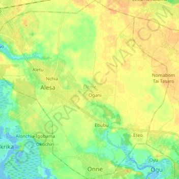
Name: Eleme topographic map, elevation, terrain.

Location: Eleme, Rivers, Nigeria (4.71742 7.07511 4.85066 7.20754)

Average elevation: 15 m

Minimum elevation: -2 m

Maximum elevation: 26 m

Other topographic maps

Click on a map to view its topography, its elevation and its terrain.

Obio/Akpor

Nigeria > Rivers

Average elevation: 14 m

Bonny Island

Nigeria > Rivers > Bonny

Average elevation: 2 m

Port Harcourt

Nigeria > Rivers > Port Harcourt

Average elevation: 7 m

Oroworokwo

Nigeria > Rivers > Port-Harcourt > Oroworokwo

Average elevation: 11 m

Igwuruta

Nigeria > Rivers > Igwuruta

Average elevation: 23 m

Okrika

Nigeria > Rivers

The average elevation of Okrika is 452 metres. It lies on the north of the Bonny River and on Okrika Island, 35 miles (56 km) upstream from the Bight of Bonny. The town can be reached by vessels of a draft of 29 feet (9 metres) or less.

Average elevation: 4 m

Okehi

Nigeria > Rivers > Okehi

Average elevation: 46 m