
Make a donation
Ferguson Mountain topographic map
Click on the map to display elevation.
Make a donation
About this map
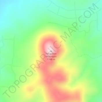
Name: Ferguson Mountain topographic map, elevation, terrain.
Location: Ferguson Mountain, Klamath County, Oregon, United States (42.48121 -121.19199 42.48131 -121.19189)
Average elevation: 1,507 m
Minimum elevation: 1,360 m
Maximum elevation: 1,739 m
Make a donation
Other topographic maps
Click on a map to view its topography, its elevation and its terrain.
Make a donation
McKenzie River
United States > Oregon > Lane County
The McKenzie River drains a region of about 1,300 square miles (3,400 km2) and is one of the primary tributaries of the Willamette River. Elevations in the watershed range from 10,358 feet (3,157 m) at the summit of the South Sister to 375 feet (114 m) at the McKenzie's mouth on the Willamette River north of…
Average elevation: 698 m
Make a donation
Cave Junction
United States > Oregon > Josephine County
Cave Junction is located on U.S. Route 199 at its junction with Oregon Route 46. It is about 30 miles or 48 kilometres southwest of Grants Pass, Oregon and 53 miles or 85 kilometres northeast of Crescent City, California. The city lies in the Illinois Valley, on the northwest slope of the Siskiyou Range, at an…
Average elevation: 410 m
John Day
United States > Oregon > Grant County
John Day is at an elevation of 3,087 feet (941 m). According to the United States Census Bureau, the city has a total area of 1.87 square miles (4.84 km2), all land.
Average elevation: 1,047 m
Cascade Locks Marine Park
United States > Oregon > Hood River County > Cascade Locks
Average elevation: 72 m
Archie Briggs Canyon Natural Area
United States > Oregon > Deschutes County > Bend
Average elevation: 1,115 m
Make a donation
Elkton
United States > Oregon > Douglas County
According to the United States Census Bureau, the city has a total area of 0.26 square miles (0.67 km2), of which, 0.23 square miles (0.60 km2) is land and 0.03 square miles (0.08 km2) is water. The elevation is 141 feet (43 m).
Average elevation: 95 m
Make a donation
Make a donation
Make a donation
Make a donation
Central Point
United States > Oregon > Jackson County
The city lies at an elevation of about 1,272 feet (388 m) along Oregon Highway 99 and Interstate 5 northwest of Medford. Jacksonville is to the south and Gold Hill to the northwest. The Central Oregon and Pacific Railroad passes through Central Point.
Average elevation: 385 m
Make a donation
Make a donation
Wilsonville
United States > Oregon > Clackamas County
Wilsonville is located on the southern edge of the Portland metropolitan area sitting at an elevation of 154 feet (47 m) above sea level. Primarily in the southwestern part of Clackamas County, the northern section is in Washington County. It is located on the north side of the Willamette River around where…
Average elevation: 60 m
Make a donation
Forest Park
United States > Oregon > Multnomah County > Portland
Solidified lava from Grande Ronde members of the Columbia River Basalt Group underlie Forest Park. About 16 million years ago during the Middle Miocene, the Columbia River ran through a lowland south of its modern channel. Eruptions from linear vents in eastern Oregon and Washington flowed down this channel…
Average elevation: 91 m
Waldo Lake Wilderness
United States > Oregon > Lane County
Ninety-eight percent of the Waldo Lake Wilderness is covered by forest on moderate to steep terrain, which ranges in elevation from 2,800 to 7,144 feet (853 to 2,177 m).
Average elevation: 1,528 m
Make a donation
Make a donation
Duck Lake Willamette River Greenway
United States > Oregon > Multnomah County > Scappoose
Average elevation: 52 m
Make a donation
Make a donation
Willamette River
United States > Oregon > Polk County
The Willamette River drains a region of 11,478 square miles (29,730 km2), which is 12 percent of the total area of Oregon. Bounded by the Coast Range to the west and the Cascade Range to the east, the river basin is about 180 miles (290 km) long and 100 miles (160 km) wide. Elevations within the watershed…
Average elevation: 72 m
Make a donation
Make a donation
Make a donation
Make a donation
Vale
United States > Oregon > Malheur County
According to the United States Census Bureau, the city has a total area of 1.14 square miles (2.95 km2), all of it land. The city has an elevation of 2,244 feet (684 m) above sea level.
Average elevation: 710 m
Make a donation
Make a donation
Make a donation
Merrill
United States > Oregon > Klamath County
Merrill is at an elevation of 4,071 feet (1,241 m) in southern Klamath County, near the Oregon–California border. It is along Oregon Route 39 southeast of Klamath Falls and northwest of Tulelake. Lower Klamath Lake and Tule Lake, both in California, are slightly south of Merrill. By highway, the city is 20…
Average elevation: 1,241 m
Malin
United States > Oregon > Klamath County
Malin is at an elevation of 4,062 feet (1,238 m) in southern Klamath County near the Oregon–California border. It is along a spur of Oregon Route 39, southeast of Klamath Falls, east of Merrill, and northeast of Tulelake. Lava Beds National Monument is to the south, nearby in California. By highway, the city…
Average elevation: 1,241 m
Make a donation
Lost Creek Lake
United States > Oregon > Jackson County
The primary purpose of the dam is flood control and is operated in conjunction with Applegate Dam to regulate water flows down the river as well as to impound water for summer use. The dam is an earthfill structure with a gated spillway and contains two hydroelectric generating units with a total capacity of…
Average elevation: 729 m
Make a donation
Make a donation
Make a donation