
Thank you for supporting this site ❤️
Make a donation
Make a donation
Le Prêcheur topographic map
Click on the map to display elevation.
Thank you for supporting this site ❤️
Make a donation
Make a donation
About this map
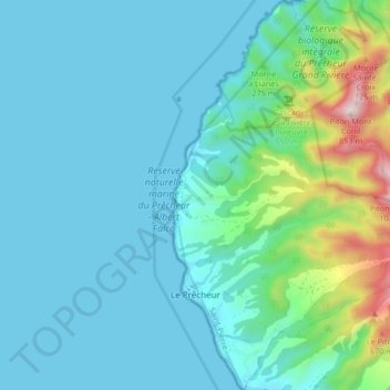
Name: Le Prêcheur topographic map, elevation, terrain.
Location: Le Prêcheur, Saint-Pierre, Martinique, 97250, France (14.78193 -61.22903 14.86219 -61.16314)
Average elevation: 136 m
Minimum elevation: 0 m
Maximum elevation: 859 m
Thank you for supporting this site ❤️
Make a donation
Make a donation
Other topographic maps
Click on a map to view its topography, its elevation and its terrain.