
Schafisheim topographic map
Interactive map
Click on the map to display elevation.
About this map
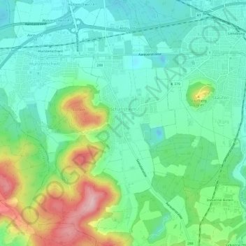
Name: Schafisheim topographic map, elevation, terrain.
Location: Schafisheim, Bezirk Lenzburg, Aargau, 5503, Schweiz (47.35589 8.12066 47.39579 8.15572)
Average elevation: 440 m
Minimum elevation: 381 m
Maximum elevation: 579 m
Other topographic maps
Click on a map to view its topography, its elevation and its terrain.
Retterswil
Schweiz > Aargau > Bezirk Lenzburg > Seon
Retterswil, Seon, Bezirk Lenzburg, Aargau, 5703, Schweiz
Average elevation: 509 m
Seon
Schweiz > Aargau > Bezirk Lenzburg
Seon, Bezirk Lenzburg, Aargau, 5703, Schweiz
Average elevation: 487 m