
Pradollano topographic map
Click on the map to display elevation.
About this map
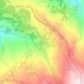
Name: Pradollano topographic map, elevation, terrain.
Average elevation: 2,281 m
Minimum elevation: 1,621 m
Maximum elevation: 2,878 m
Other topographic maps
Click on a map to view its topography, its elevation and its terrain.
Granada
Spain > Andalusia > Comarca de la Vega de Granada
Granada (Spanish: [ɡɾaˈnaða], locally [ɡɾaˈna]) is the capital city of the province of Granada, in the autonomous community of Andalusia, Spain. Granada is located at the foot of the Sierra Nevada mountains, at the confluence of four rivers, the Darro, the Genil, the Monachil and the Beiro. Ascribed to…
Average elevation: 829 m
Güéjar Sierra
Spain > Andalusia > Comarca de la Vega de Granada
Güéjar Sierra is a village and municipality located in the province of Granada, Spain. According to the INE, it had a population of 2,988 at the start of 2010. The village is situated in the north-western part of the Sierra Nevada mountain range, at an altitude of 1,088 metres. The municipality borders Pinos…
Average elevation: 1,571 m
Jardines del Triunfo
Spain > Andalusia > Comarca de la Vega de Granada > Granada
Average elevation: 719 m
Granada
Spain > Andalusia > Comarca de la Vega de Granada
Granada (/ɡrəˈnɑːdə/ grə-NAH-də; Spanish: [ɡɾaˈnaða] , locally [ɡɾaˈna]) is the capital city of the province of Granada, in the autonomous community of Andalusia, Spain. Granada is located at the foot of the Sierra Nevada mountains, at the confluence of four rivers, the Darro, the Genil, the…
Average elevation: 829 m
Granada
Spain > Andalusia > Comarca de la Vega de Granada
Granada (/ɡrəˈnɑːdə/ grə-NAH-də; Spanish: [ɡɾaˈnaða] ) is the capital city of the province of Granada, in the autonomous community of Andalusia, Spain. Granada is located at the foot of the Sierra Nevada mountains, at the confluence of four rivers, the Darro, the Genil, the Monachil and the Beiro.…
Average elevation: 829 m
Granada
Spain > Andalusia > Comarca de la Vega de Granada
Granada (/ɡrəˈnɑːdə/ grə-NAH-də; Spanish: [ɡɾaˈnaða] , locally [ɡɾaˈna]) is the capital city of the province of Granada, in the autonomous community of Andalusia, Spain. Granada is located at the foot of the Sierra Nevada mountains, at the confluence of four rivers, the Darro, the Genil, the…
Average elevation: 829 m
Palace of Charles V
Spain > Andalusia > Comarca de la Vega de Granada > Granada
Average elevation: 752 m