
Storumans kommun topographic map
Interactive map
Click on the map to display elevation.
About this map
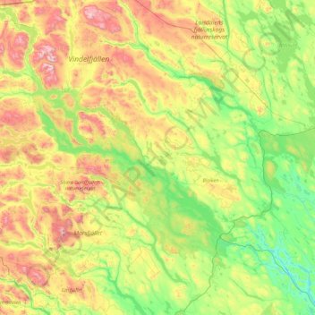
Name: Storumans kommun topographic map, elevation, terrain.
Location: Storumans kommun, Provinz Westbottnien, Schweden (64.73314 14.49877 66.15000 17.95721)
Average elevation: 588 m
Minimum elevation: 250 m
Maximum elevation: 1,733 m
Other topographic maps
Click on a map to view its topography, its elevation and its terrain.
Vilhelmina kommun
Schweden > Provinz Westbottnien
Vilhelmina kommun, Provinz Westbottnien, Schweden
Average elevation: 544 m
Umeå kommun
Schweden > Provinz Westbottnien
Umeå kommun, Provinz Westbottnien, Schweden
Average elevation: 78 m
Vindelns kommun
Schweden > Provinz Westbottnien
Vindelns kommun, Provinz Westbottnien, Schweden
Average elevation: 235 m
Lycksele kommun
Schweden > Provinz Westbottnien
Lycksele kommun, Provinz Westbottnien, Schweden
Average elevation: 356 m
Åsele kommun
Schweden > Provinz Westbottnien
Åsele kommun, Provinz Westbottnien, Schweden
Average elevation: 383 m
Skellefteå
Schweden > Provinz Westbottnien > Skellefteå
Skellefteå, Skellefteå kommun, Provinz Westbottnien, Schweden
Average elevation: 49 m