
Umeå kommun topographic map
Interactive map
Click on the map to display elevation.
About this map
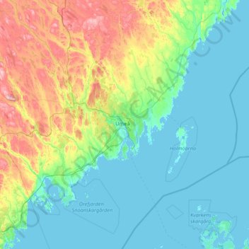
Name: Umeå kommun topographic map, elevation, terrain.
Location: Umeå kommun, Provinz Westbottnien, Schweden (63.23432 19.68105 64.39408 21.47141)
Average elevation: 78 m
Minimum elevation: -4 m
Maximum elevation: 472 m
Other topographic maps
Click on a map to view its topography, its elevation and its terrain.
Vilhelmina kommun
Schweden > Provinz Westbottnien
Vilhelmina kommun, Provinz Westbottnien, Schweden
Average elevation: 544 m
Vindelns kommun
Schweden > Provinz Westbottnien
Vindelns kommun, Provinz Westbottnien, Schweden
Average elevation: 235 m
Lycksele kommun
Schweden > Provinz Westbottnien
Lycksele kommun, Provinz Westbottnien, Schweden
Average elevation: 356 m
Åsele kommun
Schweden > Provinz Westbottnien
Åsele kommun, Provinz Westbottnien, Schweden
Average elevation: 383 m
Storumans kommun
Schweden > Provinz Westbottnien
Storumans kommun, Provinz Westbottnien, Schweden
Average elevation: 588 m
Skellefteå
Schweden > Provinz Westbottnien > Skellefteå
Skellefteå, Skellefteå kommun, Provinz Westbottnien, Schweden
Average elevation: 49 m