
Thank you for supporting this site ❤️
Make a donation
Make a donation
Minishant topographic map
Click on the map to display elevation.
Thank you for supporting this site ❤️
Make a donation
Make a donation
About this map
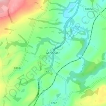
Name: Minishant topographic map, elevation, terrain.
Location: Minishant, South Ayrshire, Scotland, KA19 8ES, United Kingdom (55.37146 -4.66289 55.41146 -4.62289)
Average elevation: 79 m
Minimum elevation: 23 m
Maximum elevation: 204 m
Thank you for supporting this site ❤️
Make a donation
Make a donation
Other topographic maps
Click on a map to view its topography, its elevation and its terrain.