
Thank you for supporting this site ❤️
Make a donation
Make a donation
Wadgassen topographic map
Click on the map to display elevation.
Thank you for supporting this site ❤️
Make a donation
Make a donation
About this map
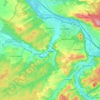
Name: Wadgassen topographic map, elevation, terrain.
Location: Wadgassen, Landkreis Saarlouis, Saarland, 66787, Deutschland (49.21890 6.71964 49.27410 6.83829)
Average elevation: 229 m
Minimum elevation: 175 m
Maximum elevation: 328 m
Thank you for supporting this site ❤️
Make a donation
Make a donation
Other topographic maps
Click on a map to view its topography, its elevation and its terrain.
Litermont
Deutschland > Saarland > Landkreis Saarlouis > Nalbach
Der im Saarland gelegene Litermont ist ein Höhenzug von bis zu 414,2 m ü. NHN und erstreckt sich größtenteils in das Nalbacher Tal, mit kleineren Ausläufern bis nach Düppenweiler.
Average elevation: 306 m
Thank you for supporting this site ❤️
Make a donation
Make a donation