
Make a donation
Kansas topographic map
Click on the map to display elevation.
Make a donation
Kansas
Kansas features a diverse yet subtle topography shaped by its position within the Great Plains. The eastern regions exhibit rolling hills and fertile soil, characterized by the Dissected Till Plains and Flint Hills, where prairie grasses thrive on rocky terrain. As you move westward, the land gradually ascends in elevation, transitioning into the High Plains, a gently sloping and open landscape that culminates near the Colorado border at Mount Sunflower, the state's highest point at 4,039 feet above sea level. Kansas's lowest elevation, 679 feet, is found along the Verdigris River. The state's rivers, including the Kansas and Arkansas, carve through these plains, adding to its agricultural richness while occasionally creating distinct valleys and bluffs.
Make a donation
About this map
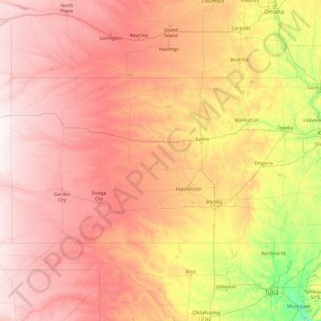
Name: Kansas topographic map, elevation, terrain.
Location: Kansas, United States (36.99307 -102.05179 40.00323 -94.58820)
Average elevation: 601 m
Minimum elevation: 150 m
Maximum elevation: 1,302 m
Make a donation
Other topographic maps
Click on a map to view its topography, its elevation and its terrain.
San Francisco Bay Area
United States > California > San Francisco
The San Francisco Bay Area is characterized by a diverse and dynamic topography shaped by geological processes over millions of years. This region features a combination of coastal plains, steep hills, and rugged mountains, all influenced by the tectonic activity associated with the nearby San Andreas Fault…
Average elevation: 113 m
Appalachian Mountains
United States > North Carolina > Yancey County
The Appalachian Mountains (French: Appalaches), often called the Appalachians, are a system of mountains in eastern to northeastern North America. The Appalachians first formed roughly 480 million years ago during the Ordovician Period. They once reached elevations similar to those of the Alps and the Rocky…
Average elevation: 1,463 m
Cajon Pass
United States > California > San Bernardino County
Cajon Pass (/kəˈhoʊn/; Spanish: Puerto del Cajón or Paso del Cajón) is a mountain pass between the San Bernardino Mountains to the east and the San Gabriel Mountains to the west in Southern California. Created by the movements of the San Andreas Fault, it has an elevation of 3,777 ft (1,151 m). Located in…
Average elevation: 1,169 m
Make a donation
Scottsdale
United States > Arizona > Maricopa County > Scottsdale
The city is in the Salt River Valley, or the "Valley of the Sun," in the northern reaches of the Sonoran Desert. Scottsdale, 31 mi (50 km) long and 11.4 mi (18.3 km) wide at its widest point, shares boundaries with many other municipalities and entities. On the west, Scottsdale is bordered by Phoenix, Paradise…
Average elevation: 414 m
Boston
United States > Massachusetts > Suffolk County > Boston
Boston has an area of 89.63 sq mi (232.1 km2)—48.4 sq mi (125.4 km2) (54%) of land and41.2 sq mi (106.7 km2) (46%) of water. The city's official elevation, as measured at Logan International Airport, is 19 ft (5.8 m) above sea level. The highest point in Boston is Bellevue Hill at 330 ft (100 m) above sea…
Average elevation: 26 m
Little Jimmy Spring
United States > California > Los Angeles County > Cedar Springs
Average elevation: 2,188 m
Make a donation
Mauna Kea
United States > Hawaii > Hawaiʻi County
Mauna Kea (/ˌmaʊnə ˈkeɪə/; Hawaiian: [ˈmɐwnə ˈkɛjə]; abbreviation for Mauna a Wākea) is a dormant volcano on the island of Hawaiʻi. Its peak is 4,207.3 m (13,803 ft) above sea level, making it the highest point in the state of Hawaiʻi and second-highest peak of an island on Earth. The peak is…
Average elevation: 3,978 m
Santa Cruz Mountains
United States > California > Santa Clara County
The Santa Cruz Mountains are a region of great biological diversity, encompassing cool, moist coastal ecosystems as well as warm, dry chaparral. Much of the area in the Santa Cruz mountains is considered temperate rainforest. In valleys and moist ocean-facing slopes some of the southernmost coast redwoods…
Average elevation: 230 m
Indianapolis
United States > Indiana > Indianapolis
Indianapolis is within the Tipton Till Plain, a flat to gently sloping terrain underlain by glacial deposits known as till. The lowest point in the city is about 650 feet (198 m) above mean sea level, with the highest natural elevation at about 900 feet (274 m) above sea level. Few hills or short ridges, known…
Average elevation: 241 m
Baltimore
United States > Maryland > Baltimore
Baltimore is in north-central Maryland on the Patapsco River close to where it empties into the Chesapeake Bay. The city is also located on the fall line between the Piedmont Plateau and the Atlantic coastal plain, which divides Baltimore into "lower city" and "upper city". The city's elevation ranges from sea…
Average elevation: 65 m
Make a donation
Columbus
United States > Ohio > Franklin County > Columbus
The confluence of the Scioto and Olentangy rivers is just north-west of Downtown Columbus. Several smaller tributaries course through the Columbus metropolitan area, including Alum Creek, Big Walnut Creek, and Darby Creek. Columbus is considered to have relatively flat topography thanks to a large glacier that…
Average elevation: 255 m
Appalachian Mountains
United States > North Carolina > Yancey County
The Appalachian Mountains (French: Appalaches), often called the Appalachians, are a system of mountains in eastern to northeastern North America. The Appalachians first formed roughly 480 million years ago during the Ordovician Period. They once reached elevations similar to those of the Alps and the Rocky…
Average elevation: 1,463 m
Estes Park
United States > Colorado > Larimer County
Estes Park sits at an elevation of 7,522 feet (2,293 m) on the front range of the Rocky Mountains at the eastern entrance of the Rocky Mountain National Park. Its location is 40°22′22″N 105°31′09″W / 40.372856°N 105.519136°W / 40.372856; -105.519136. Its north, south and east extremities…
Average elevation: 2,543 m
Make a donation
Make a donation
Make a donation
Kula
United States > Hawaii > Maui County
Kula is a district and census-designated place (CDP) of Maui, Hawaii, that stretches across the "up-country", the western-facing slopes of Haleakalā, from Makawao to Kanaio. Most of the residential areas lie between about 500 to 1,100 m (1,600 to 3,600 ft) in elevation. The district has traditionally been…
Average elevation: 740 m
Snake River
Mountain ranges in the Snake watershed include the Teton Range, Bitterroot Range, Clearwater Mountains, Seven Devils Mountains, and the extreme northwestern end of the Wind River Range. Grand Teton is the highest point in the Snake River watershed, reaching 13,775 feet (4,199 m) in elevation. The elevation of…
Average elevation: 644 m
Make a donation
Uinta Mountains
The high Uintas were extensively glaciated during the last ice age, and most of the large stream valleys on both the north and south sides of the range held long valley glaciers. However, despite reaching to over 13,500 feet (4,110 m) in elevation, the climate today is sufficiently dry that no glaciers…
Average elevation: 2,363 m
Palm Harbor
United States > Florida > Pinellas County
Palm Harbor is characterized by its unique topography, which features a relatively rare hilly landscape for the region. Unlike much of the surrounding areas in Pinellas County, which are predominantly flat, Palm Harbor includes elevations that can reach up to about 75 feet above sea level. This elevation gives…
Average elevation: 9 m
Make a donation
Evergreen
United States > Colorado > Jefferson County
Evergreen sits at an elevation of 7,220 feet (2,200 m) in the Rocky Mountains, 19 miles west of Denver, Colorado. Its addresses are oriented according to the Street_system_of_Denver.
Average elevation: 2,309 m
Make a donation
Ramona
United States > California > San Diego County
In January 2006, Ramona Valley was designated the country's 162nd American Viticultural Area (AVA) by the Alcohol and Tobacco Tax and Trade Bureau, which recognized the area for its distinctive microclimate, elevation, and soil attributes.
Average elevation: 469 m
Georgetown
United States > Texas > Georgetown
The city is located on the northeastern edge of Texas Hill Country. Portions of Georgetown are located on either side of the Balcones Escarpment, a fault line in which the areas roughly east of IH-35 are flat and characterized by having black, fertile soils of the Blackland Prairie, and the west side of the…
Average elevation: 219 m
Make a donation
Rocky Mountains
United States > Wyoming > Teton County
Agriculture and forestry are major industries. Agriculture includes dryland and irrigated farming and livestock grazing. Livestock are frequently moved between high-elevation summer pastures and low-elevation winter pastures, a practice known as transhumance.
Average elevation: 2,292 m
Make a donation
Navarre
United States > Florida > Santa Rosa County
Navarre is located at 30°24′04″N 86°51′47″W / 30.401°N 86.863°W / 30.401; -86.863Coordinates: 30°24′04″N 86°51′47″W / 30.401°N 86.863°W / 30.401; -86.863. It is located within a portion of the Florida Panhandle observing the Central Time Zone. Elevation is at an average of 10 feet (3.0 m).
Average elevation: 4 m
Make a donation
Cuyahoga Valley National Park
United States > Ohio > Cuyahoga County > Independence
Average elevation: 209 m
Make a donation
Make a donation
Anna Maria island
United States > Florida > Manatee County
Anna Maria Island features a flat, sandy topography typical of a barrier island on the Gulf Coast. With an average elevation of around 15 feet above sea level, the terrain includes broad beaches, low dunes, and narrow stretches of sandy soil, making it highly vulnerable to storm surges and tidal flooding. The…
Average elevation: 2 m
Make a donation
Crowley Lake
United States > California > Mono County
Crowley Lake is a census-designated place in Mono County, California. Crowley Lake sits at an elevation of 6,939 feet (2,115 m). The 2020 United States census reported Crowley Lake's population was 980.
Average elevation: 2,251 m
Highlands
United States > North Carolina > Macon County > Highlands
Highlands was founded in 1875 after its two founders, Samuel Truman Kelsey and Clinton Carter Hutchinson, drew lines from Chicago to Savannah and from New Orleans to New York City. They felt that the place where these lines met would eventually become a great trading center and commercial crossroads. Highlands…
Average elevation: 1,090 m
Bear Lake
United States > Utah > Rich County > Garden City
Formed in a half graben valley straddling the Idaho-Utah border, the lake has an approximate area of 109 square miles (280 km2) and sits at an elevation of 5,924 feet (1,806 m) along the northeast side of the Wasatch Range and the east side of the Bear River Mountains.
Average elevation: 2,038 m
Make a donation
Tug Hill
United States > New York > Oswego County
The core Tug Hill region encompasses 150,000 acres (610 km2) of unbroken, generally second-growth, northern hardwood forest, and is drained by a vast network of streams. Important rivers and streams whose headwaters are located within the Tug Hill region include the Mohawk River, Deer River, Salmon River, Mad…
Average elevation: 109 m
Make a donation
Make a donation
Estes Park
United States > Colorado > Larimer County
Estes Park sits at an elevation of 7,522 feet (2,293 m) on the front range of the Rocky Mountains at the eastern entrance of the Rocky Mountain National Park. Its north, south and east extremities border the Roosevelt National Forest. Lumpy Ridge lies immediately north of Estes Park.
Average elevation: 2,543 m
Dorrington
United States > California > Calaveras County
According to the United States Census Bureau, the CDP has a total area of 3.7 square miles (9.6 km2), 99.86% of it land. The elevation is 4,800 feet ASL.
Average elevation: 1,464 m
Blue Ridge Mountains
United States > Virginia > Botetourt County
Although the term "Blue Ridge" is sometimes applied exclusively to the eastern edge or front range of the Appalachian Mountains, the geological definition of the Blue Ridge province extends westward to the Ridge and Valley area, encompassing the Great Smoky Mountains, the Great Balsams, the Roans, the Blacks,…
Average elevation: 460 m
Make a donation
Rico
United States > Colorado > Dolores County
Rico experiences an alpine subarctic climate (Köppen climate classification Dfc) with long, cold, very snowy winters and short, cool summers due to the high altitude and high precipitation year-round due to orographic lift.
Average elevation: 2,861 m
Parrish
United States > Florida > Manatee County
Parrish features a predominantly flat terrain with an average elevation of approximately 36 feet above sea level. The area's landscape is characterized by gently rolling hills and low-lying regions, making it typical of the Central Florida topography. Surrounding Parrish are numerous wetlands and drainage…
Average elevation: 12 m
Johnston Island
The climate is tropical but generally dry. Northeast trade winds are consistent and there is little seasonal temperature variation. With elevation ranging from sea level to 5 m (16 ft) at Summit Peak, the islands contain some low-growing vegetation and palm trees on mostly flat terrain, and no natural fresh…
Average elevation: 1 m
Make a donation
Port Charlotte
United States > Florida > Charlotte County
Port Charlotte is characterized by a predominantly flat and low-lying terrain, typical of Florida’s coastal landscape. The area features a network of waterways, including the Peace River and Charlotte Harbor, which provide ample opportunities for recreational activities like boating and fishing. Elevations…
Average elevation: 4 m
Make a donation
Mount Hood
United States > Oregon > Hood River County
Timberline Lodge is a National Historic Landmark located on the southern flank of Mount Hood just below Palmer Glacier, with an elevation of about 6,000 ft (1,800 m).
Average elevation: 2,716 m
Make a donation
Little Saint James Island
United States > United States Virgin Islands > Saint Thomas - Saint John District
Average elevation: 1 m
Make a donation
Moonridge
United States > California > San Bernardino County > Big Bear Lake
Average elevation: 2,211 m
Nokomis
United States > Florida > Sarasota County
Nokomis features a predominantly flat and low-lying terrain characteristic of the coastal region. The elevation in Nokomis rarely exceeds 15 feet above sea level, contributing to its vulnerability to tidal influences and storm surges. The area is interspersed with wetlands and mangroves, particularly near the…
Average elevation: 5 m
Make a donation
San Fernando Valley
United States > California > Los Angeles County > Los Angeles
Average elevation: 496 m
Make a donation