
Thank you for supporting this site ❤️
Make a donation
Make a donation
Ronneby kommun topographic map
Click on the map to display elevation.
Thank you for supporting this site ❤️
Make a donation
Make a donation
About this map
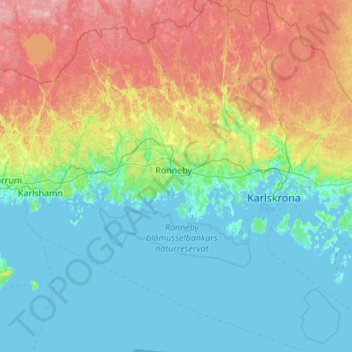
Name: Ronneby kommun topographic map, elevation, terrain.
Location: Ronneby kommun, Blekinge County, Sweden (55.89404 14.93062 56.50061 15.52399)
Average elevation: 45 m
Minimum elevation: -2 m
Maximum elevation: 183 m
Thank you for supporting this site ❤️
Make a donation
Make a donation
Other topographic maps
Click on a map to view its topography, its elevation and its terrain.
Karlskrona
When the city was founded in 1680, it was primarily thought of as a military city, with many defenses and fortifications exploiting the particular topography of the city. Some fortifications were located on the main island (Trossö) such as the Bastion Aurora, built at the beginning of the 18th century, but…
Average elevation: 25 m
Thank you for supporting this site ❤️
Make a donation
Make a donation
Thank you for supporting this site ❤️
Make a donation
Make a donation
Thank you for supporting this site ❤️
Make a donation
Make a donation