
Odisha topographic map
Interactive map
Click on the map to display elevation.
About this map
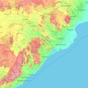
Name: Odisha topographic map, elevation, terrain.
Location: Odisha, India (17.79490 81.38859 22.56765 87.48580)
Average elevation: 227 m
Minimum elevation: -1 m
Maximum elevation: 1,584 m
Three-quarters of the state is covered in mountain ranges. Deep and broad valleys have been made in them by rivers. These valleys have fertile soil and are densely populated. Odisha also has plateaus and rolling uplands, which have lower elevation than the plateaus. The highest point in the state is Deomali at 1,672 metres. The other high peaks are: Sinkaram (1,620 m), Golikoda (1,617 m), and Yendrika (1,582 metres).
Other topographic maps
Click on a map to view its topography, its elevation and its terrain.
Ward 41
India > Odisha > Bhubaneswar Municipal Corporation
Ward 41, South East Zone, Bhubaneswar Municipal Corporation, Khordha, Odisha, India
Average elevation: 39 m
Ward 18
India > Odisha > Bhubaneswar Municipal Corporation
Ward 18, North Zone, Bhubaneswar Municipal Corporation, Cuttack, Odisha, India
Average elevation: 21 m