
Make a donation
Colorado topographic map
Click on the map to display elevation.
Make a donation
Colorado
Colorado's topography is characterized by a diverse range of elevations and landforms, making it one of the most geologically varied states in the U.S. The state is dominated by the Rocky Mountains, which run north to south and include the highest peak in the contiguous United States, Mount Elbert, towering at 14,440 feet (4,401 meters). This mountainous region features dramatic peaks, deep valleys, and extensive alpine forests. In contrast, the eastern plains consist of rolling hills and flatlands that gently rise towards the foothills of the Rockies. The terrain is punctuated by rivers, lakes, and canyons, with significant geological formations such as the Flatirons and the iconic Pikes Peak. Colorado's elevation varies significantly, ranging from around 3,315 feet (1,010 meters) at the Arikaree River to over 14,000 feet (4,267 meters) in the mountains, contributing to its unique ecosystems and recreational opportunities.
Make a donation
About this map
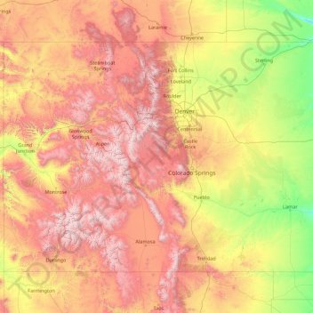
Name: Colorado topographic map, elevation, terrain.
Location: Colorado, United States (36.99252 -109.06019 41.00340 -102.04159)
Average elevation: 2,060 m
Minimum elevation: 1,020 m
Maximum elevation: 4,379 m
Make a donation
Other topographic maps
Click on a map to view its topography, its elevation and its terrain.
Make a donation
Mancos
United States > Colorado > Montezuma County
According to the United States Census Bureau, Mancos has a total area of 0.6 square miles (1.6 km2), all of it recorded as land. The town is located in the Mancos River valley at an elevation of approximately 7,000 feet (2,100 m). The Mancos River was named by Spanish explorers (Rio de los Mancos - "River of…
Average elevation: 2,166 m
Make a donation
Make a donation
Make a donation
Wesley Chapel
United States > Florida > Pasco County
According to the United States Census Bureau, the CDP has a total area of 6.1 square miles (16 km2), of which 6.1 square miles (16 km2) is land and 0.04 square miles (0.10 km2) (0.49%) is water. The elevation is about 100 feet (30 m), combined with an inland location, creates more temperature variation in the…
Average elevation: 19 m
Burkhardt
United States > Wisconsin > Saint Croix County > Town of Saint Joseph
Average elevation: 273 m
Make a donation
Make a donation
Make a donation
Forrest Hill
United States > Connecticut > Northeastern Connecticut Planning Region > Woodstock
Average elevation: 154 m
Make a donation
Make a donation
Make a donation
Make a donation
Allensworth
United States > California > Tulare County
Allensworth sits at an elevation of 213 feet (65 m), the same elevation as the huge and historically important Tulare Lake shore when it was full. The community is located in the ZIP Code 93219 and in the area code 661.
Average elevation: 63 m