
Ejigbo topographic map
Click on the map to display elevation.
Ejigbo
Ejigbo is a prominent city in Yoruba Land and the headquarters of Ejigbo Local Government Area, one of the oldest local government areas of Osun State in Nigeria. Ejigbo is strategically placed in the middle of the region, as 35 kilometres (22 mi) north-east of Iwo, 30 km (19 mi) from Ogbomoso in the north and 24 km (15 mi) from Ede in the south-east. It is about 40 km (25 mi) north-west of Osogbo, the capital of Osun State, and about 95 km (59 mi) north-east of Ibadan. It is part of the Ede North/Ede South/Egbedore/Ejigbo federal constituency. The population is 138,357 according to the GeoNames geographical database. The average elevation is 426 metres (1,398 ft).
About this map
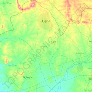
Name: Ejigbo topographic map, elevation, terrain.
Location: Ejigbo, Osun State, 232118, Nigeria (7.65254 4.07249 7.97123 4.36729)
Average elevation: 317 m
Minimum elevation: 225 m
Maximum elevation: 548 m
Other topographic maps
Click on a map to view its topography, its elevation and its terrain.