Geolocate

Remo North topographic map

Interactive map

Click on the map to display elevation.

About this map

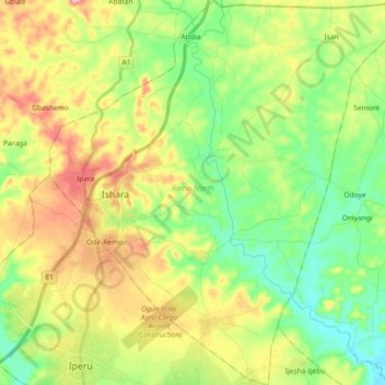
Name: Remo North topographic map, elevation, terrain.

Location: Remo North, Ogun State, Nigeria (6.90237 3.64958 7.08358 3.82361)

Average elevation: 92 m

Minimum elevation: 21 m

Maximum elevation: 201 m

Other topographic maps

Click on a map to view its topography, its elevation and its terrain.

Ewekoro

Nigeria > Ogun State > Ewekoro

Average elevation: 24 m

Oju Ota

Nigeria > Ogun State > Yewa South

Average elevation: 40 m

Itere

Nigeria > Ogun State > Ado Odo/Ota

Average elevation: 7 m

Otta

Nigeria > Ogun State > Ado Odo/Ota

Average elevation: 55 m

Ipokia

Nigeria > Ogun State > Ipokia

Average elevation: 45 m

Mawuko

Nigeria > Ogun State > Abeokuta North

Average elevation: 66 m

Abeokuta

Nigeria > Ogun State > Abeokuta South

Average elevation: 95 m

Agbohun

Nigeria > Ogun State > Obafemi Owode > Agbohun

Average elevation: 128 m

Oke Mosan

Nigeria > Ogun State > Obafemi Owode > Oke Mosan

Average elevation: 102 m

Lukosi

Nigeria > Ogun State > Obafemi Owode > Lukosi

Average elevation: 17 m