
Make a donation
Yalova topographic map
Click on the map to display elevation.
Make a donation
About this map
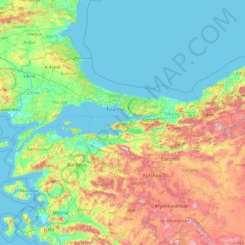
Name: Yalova topographic map, elevation, terrain.
Location: Yalova, Marmara Region, Turkey (37.97954 26.56870 43.17954 31.76870)
Average elevation: 404 m
Minimum elevation: -2 m
Maximum elevation: 2,703 m
Make a donation
Other topographic maps
Click on a map to view its topography, its elevation and its terrain.
Make a donation
Batman
The province occupies an area of 4,477 km2 (1,729 sq mi). It lies in a mountainous area with the average elevation of 550 meters which contains several thousands of caves. The tallest mountains are Sason Dağları (2500 m), Meleto (2967 m), Kuşaklı Dağı (1947 m), Avcı Dağı (2121 m), Meydanok Tepesi…
Average elevation: 941 m
Bakırköy
While the average elevation is 20-30 meters throughout Bakırköy, this value rises to 70 meters in the north of the district. The ridges slope north-south towards the Marmara Sea. The coastal length of Bakırköy is 13 km, with small cliffs in Yeşilköy and Yeşilyurt neighborhoods and a sandy beach in Florya.
Average elevation: 21 m
Taurus Mountains
The mountains have a Mediterranean climate, with dry summers and rainy winters. Temperatures vary with elevation, with warm winters on the lower coastal slopes and cold winters in the high mountains and in the interior.
Average elevation: 828 m
Make a donation
Lake Van
Lake Van (Turkish: Van Gölü; Armenian: Վանա լիճ, romanized: Vana lič̣; Kurdish: Gola Wanê) is the largest lake in Turkey. It lies in the Eastern Anatolia Region of Turkey in the provinces of Van and Bitlis, in the Armenian highlands. It is a saline soda lake, receiving water from many small streams…
Average elevation: 1,902 m
Antalya
The highest point of the Taurus mountains is Akdağ at an altitude of 3025 metres. Located to the northwest of the city centre and at a distance of 50 km (31 mi) is the Saklıkent ski and recreation centre on Beydağları. Here one can ski and then go down to the shore and into the sea during the months of…
Average elevation: 644 m
Make a donation
Oludeniz
Ölüdeniz offer a variety of diving opportunities with regard to its crystal clear waters and rich underwater caves and fauna. Scuba diving is the most popular underwater activity. Local diving agencies provide courses and required scuba diving licences. Snorkelling is another diving activity and many sites…
Average elevation: 541 m
Make a donation
Make a donation
Anatolia
Anatolia (Turkish: Anadolu), also known as Asia Minor, is a peninsula in West Asia that makes up the majority of the land area of Turkey. It is the westernmost protrusion of Asia and is geographically bounded by the Mediterranean Sea to the south, the Aegean Sea to the west, the Turkish Straits to the…
Average elevation: 518 m
Batman
The province occupies an area of 4,477 km2 (1,729 sq mi). It lies in a mountainous area with the average elevation of 550 meters which contains several thousands of caves. The tallest mountains are Sason Dağları (2500 m), Meleto (2967 m), Kuşaklı Dağı (1947 m), Avcı Dağı (2121 m), Meydanok Tepesi…
Average elevation: 941 m
Make a donation
Make a donation
Make a donation
Antakya
Antakya's climate is classified as hot-summer Mediterranean (Köppen: Csa) or dry-summer humid subtropical (Trewartha: Cf or wet Cs). The city experiences hot, dry summers, and mild, wet winters; though its higher altitude allows for lower temperatures than the coast.
Average elevation: 385 m
Kırşehir
Kırşehir Province (Turkish: Kırşehir ili) is a province in central Turkey, forming part of the Central Anatolia Region. Its area is 6,584 km2, and its population is 244,519 (2022). It stands on the North Anatolian Fault, and is currently in an earthquake warning zone. The average elevation is approximately…
Average elevation: 1,079 m
Make a donation
Make a donation
Make a donation
Çaykara
Çaykara (Romeika: Kadahor, Κατωχώρι) is a municipality and district of Trabzon Province, Turkey. Its area is 574 km2, and its population is 13,070 (2022). As of 2023, the Mayor of Çaykara is Hanefi Tok (AKP). Çaykara village lies in a V-shaped valley along the Solaklı River in the Pontic Mountains,…
Average elevation: 1,788 m
Make a donation
Anatolia
Anatolia (Turkish: Anadolu), also known as Asia Minor, is a peninsula in West Asia that makes up the majority of the land area of Turkey. It is the westernmost protrusion of Asia and is geographically bounded by the Mediterranean Sea to the south, the Aegean Sea to the west, the Turkish Straits to the…
Average elevation: 518 m
Make a donation
Make a donation
Make a donation
Karagöl Sahara National Park
The national park covers an area of 3,251 ha (8,030 acres) at an average elevation of 1,800 m (5,900 ft) above mean sea level.
Average elevation: 1,885 m
Make a donation
Make a donation
Gerede
Gerede is a town in Bolu Province in the Black Sea region of Turkey. It is located on the highway from Istanbul to Ankara (approximately 150 km (93.21 mi) from Ankara, where the road to the Black Sea coast branches off). It is the seat of Gerede District. Its population is 23,547 (2021). Elevation is about…
Average elevation: 1,368 m
Make a donation
Bağcılar
Bağcılar is located on the European side of Istanbul, within the service boundaries of Istanbul Metropolitan Municipality. Its area is 22 km2 (8.5 sq mi). The district is now known as an immigrant quarter. It lies between E-5 and TEM. In the south Bahçelievler, in the west Küçükçekmece, in the northwest…
Average elevation: 85 m
Make a donation
Make a donation
Make a donation
Make a donation
Make a donation
Make a donation
Make a donation