
Make a donation
Cold Springs topographic map
Click on the map to display elevation.
Make a donation
About this map
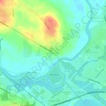
Name: Cold Springs topographic map, elevation, terrain.
Average elevation: 122 m
Minimum elevation: 106 m
Maximum elevation: 161 m
Make a donation
Other topographic maps
Click on a map to view its topography, its elevation and its terrain.
Skaneateles Lake
United States > New York > Onondaga County > Town of Skaneateles
Skaneateles Lake (/ˌskæniˈætləs/ SKAN-ee-AT-ləs, locally /ˌskɪn-/ SKIN-) is one of the Finger Lakes in central New York in the United States. The name Skaneateles means long lake in one of the local Iroquoian languages. The lake is sometimes referred to as "The Roof Garden of the Lakes" because its…
Average elevation: 349 m
Make a donation
Town of Skaneateles
United States > New York > Onondaga County > Town of Skaneateles
Average elevation: 276 m
Green Lakes State Park
United States > New York > Onondaga County > Village of Fayetteville > Town of Manlius
Average elevation: 166 m
Village of Fabius
United States > New York > Onondaga County > Town of Fabius
Average elevation: 402 m
Make a donation
Make a donation