
Velas topographic map
Interactive map
Click on the map to display elevation.
About this map
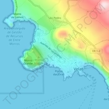
Name: Velas topographic map, elevation, terrain.
Location: Velas, Velas (São Jorge), Velas, Açores, Portugal (38.67677 -28.22435 38.68988 -28.20203)
Average elevation: 83 m
Minimum elevation: -6 m
Maximum elevation: 383 m
Other topographic maps
Click on a map to view its topography, its elevation and its terrain.
Toledo
Portugal > Velas > Santo Amaro
Toledo, Santo Amaro, Velas, Açores, 9800-338, Portugal
Average elevation: 374 m
Fajã do Ouvidor
Portugal > Velas > Fajã do Ouvidor
Fajã do Ouvidor, Norte Grande (Neves), Velas, Açores, Portugal
Average elevation: 202 m