
Thank you for supporting this site ❤️
Make a donation
Make a donation
Cooper City topographic map
Click on the map to display elevation.
Thank you for supporting this site ❤️
Make a donation
Make a donation
About this map
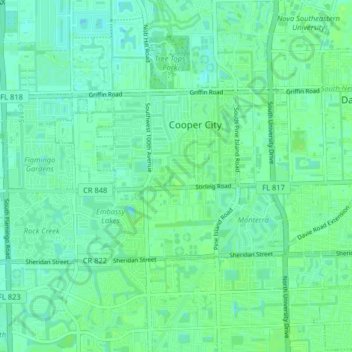
Name: Cooper City topographic map, elevation, terrain.
Location: Cooper City, Broward County, Florida, United States (26.02953 -80.32982 26.06480 -80.24908)
Average elevation: 6 m
Minimum elevation: 1 m
Maximum elevation: 10 m
Thank you for supporting this site ❤️
Make a donation
Make a donation
Other topographic maps
Click on a map to view its topography, its elevation and its terrain.
Thank you for supporting this site ❤️
Make a donation
Make a donation
Ro-Len Lake Gardens
United States > Florida > Broward County > Hallandale Beach
Average elevation: 7 m
Thank you for supporting this site ❤️
Make a donation
Make a donation
Bonita Bay
United States > Florida > Broward County > Fort Lauderdale > Soroka Shores
Average elevation: 4 m
Thank you for supporting this site ❤️
Make a donation
Make a donation
Bonita Bay
United States > Florida > Broward County > Fort Lauderdale > Soroka Shores
Average elevation: 4 m
Thank you for supporting this site ❤️
Make a donation
Make a donation
Thank you for supporting this site ❤️
Make a donation
Make a donation
Thank you for supporting this site ❤️
Make a donation
Make a donation
Thank you for supporting this site ❤️
Make a donation
Make a donation
Thank you for supporting this site ❤️
Make a donation
Make a donation
Thank you for supporting this site ❤️
Make a donation
Make a donation
Fort Lauderdale Beach
United States > Florida > Broward County > Fort Lauderdale > Birch Ocean Front
Average elevation: 3 m