
Thank you for supporting this site ❤️
Make a donation
Make a donation
Konshisha topographic map
Click on the map to display elevation.
Thank you for supporting this site ❤️
Make a donation
Make a donation
About this map
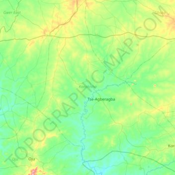
Name: Konshisha topographic map, elevation, terrain.
Location: Konshisha, Benue State, Nigeria (6.81322 8.43853 7.42034 8.95224)
Average elevation: 118 m
Minimum elevation: 48 m
Maximum elevation: 382 m
Thank you for supporting this site ❤️
Make a donation
Make a donation
Other topographic maps
Click on a map to view its topography, its elevation and its terrain.