
Thank you for supporting this site ❤️
Make a donation
Make a donation
West Hebron topographic map
Click on the map to display elevation.
Thank you for supporting this site ❤️
Make a donation
Make a donation
About this map
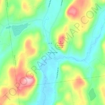
Name: West Hebron topographic map, elevation, terrain.
Average elevation: 209 m
Minimum elevation: 135 m
Maximum elevation: 336 m
Thank you for supporting this site ❤️
Make a donation
Make a donation
Other topographic maps
Click on a map to view its topography, its elevation and its terrain.
Thank you for supporting this site ❤️
Make a donation
Make a donation
Thank you for supporting this site ❤️
Make a donation
Make a donation
Village of Hudson Falls
United States > New York > Washington County > Town of Kingsbury
Average elevation: 82 m
Town of Argyle
United States > New York > Washington County
In the eastern part of the town, elevations increase, with several mountains reaching over 1,000 feet in height; with the highest being a few feet over 1,120 feet in height north of the hamlet of Goose Island. Two lakes, which both have extensive seasonal camps and year-round homes, are in this portion of the…
Average elevation: 130 m
Thank you for supporting this site ❤️
Make a donation
Make a donation