
Make a donation
Alabama topographic map
Click on the map to display elevation.
Make a donation
Alabama
Alabama is bordered by the states of Tennessee to the north, Georgia to the east, Florida to the south, and Mississippi to the west. Alabama has coastline at the Gulf of Mexico, in the extreme southern edge of the state. The state ranges in elevation from sea level at Mobile Bay to more than 2,000 feet (610 m) in the northeast, to Mount Cheaha at 2,413 ft (735 m).
Make a donation
About this map
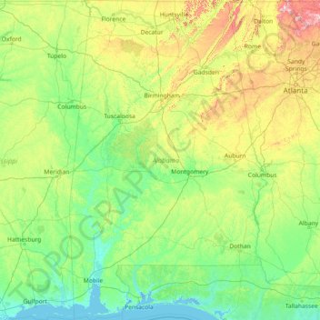
Name: Alabama topographic map, elevation, terrain.
Location: Alabama, United States (30.14338 -88.47310 35.00811 -84.88829)
Average elevation: 136 m
Minimum elevation: -3 m
Maximum elevation: 1,232 m
Make a donation
Other topographic maps
Click on a map to view its topography, its elevation and its terrain.
Mancos
United States > Colorado > Montezuma County
According to the United States Census Bureau, Mancos has a total area of 0.6 square miles (1.6 km2), all of it recorded as land. The town is located in the Mancos River valley at an elevation of approximately 7,000 feet (2,100 m). The Mancos River was named by Spanish explorers (Rio de los Mancos - "River of…
Average elevation: 2,166 m
Make a donation
Make a donation
Make a donation
Make a donation
Wesley Chapel
United States > Florida > Pasco County
According to the United States Census Bureau, the CDP has a total area of 6.1 square miles (16 km2), of which 6.1 square miles (16 km2) is land and 0.04 square miles (0.10 km2) (0.49%) is water. The elevation is about 100 feet (30 m), combined with an inland location, creates more temperature variation in the…
Average elevation: 19 m
Burkhardt
United States > Wisconsin > Saint Croix County > Town of Saint Joseph
Average elevation: 273 m
Make a donation
Make a donation
Forrest Hill
United States > Connecticut > Northeastern Connecticut Planning Region > Woodstock
Average elevation: 154 m
Make a donation
Make a donation
Make a donation
Make a donation
Make a donation
Allensworth
United States > California > Tulare County
Allensworth sits at an elevation of 213 feet (65 m), the same elevation as the huge and historically important Tulare Lake shore when it was full. The community is located in the ZIP Code 93219 and in the area code 661.
Average elevation: 63 m