
Make a donation
Delaware topographic map
Click on the map to display elevation.
Make a donation
Delaware
Delaware is on a level plain, with the lowest mean elevation of any state in the nation. Its highest elevation, located at Ebright Azimuth, near Concord High School, is less than 450 feet (140 m) above sea level. The northernmost part of the state is part of the Piedmont Plateau with hills and rolling surfaces.
Make a donation
About this map
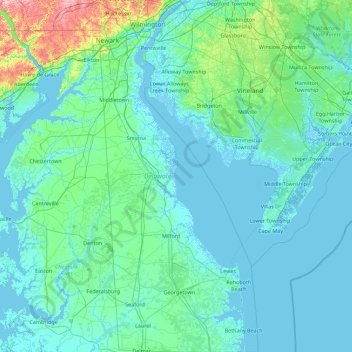
Name: Delaware topographic map, elevation, terrain.
Location: Delaware, United States (38.45118 -75.78902 39.83951 -74.98494)
Average elevation: 16 m
Minimum elevation: -4 m
Maximum elevation: 205 m
Make a donation
Other topographic maps
Click on a map to view its topography, its elevation and its terrain.
Mancos
United States > Colorado > Montezuma County
According to the United States Census Bureau, Mancos has a total area of 0.6 square miles (1.6 km2), all of it recorded as land. The town is located in the Mancos River valley at an elevation of approximately 7,000 feet (2,100 m). The Mancos River was named by Spanish explorers (Rio de los Mancos - "River of…
Average elevation: 2,166 m
Make a donation
Make a donation
Make a donation
Wesley Chapel
United States > Florida > Pasco County
According to the United States Census Bureau, the CDP has a total area of 6.1 square miles (16 km2), of which 6.1 square miles (16 km2) is land and 0.04 square miles (0.10 km2) (0.49%) is water. The elevation is about 100 feet (30 m), combined with an inland location, creates more temperature variation in the…
Average elevation: 19 m
Make a donation
Burkhardt
United States > Wisconsin > Saint Croix County > Town of Saint Joseph
Average elevation: 273 m
Make a donation
Make a donation
Forrest Hill
United States > Connecticut > Northeastern Connecticut Planning Region > Woodstock
Average elevation: 154 m
Make a donation
Make a donation
Make a donation
Make a donation
Make a donation
Allensworth
United States > California > Tulare County
Allensworth sits at an elevation of 213 feet (65 m), the same elevation as the huge and historically important Tulare Lake shore when it was full. The community is located in the ZIP Code 93219 and in the area code 661.
Average elevation: 63 m