
Make a donation
Gunung Angsi topographic map
Click on the map to display elevation.
Make a donation
Gunung Angsi
Part of the Titiwangsa Mountains, it is the seventh tallest mountain in the state, behind Mts. Besar Hantu, Hantu Kecil, Telapak Buruk, Berembun and Datuk, with an elevation of 2,707 feet (825 m).
Make a donation
About this map
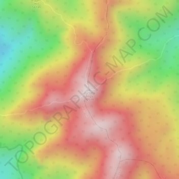
Name: Gunung Angsi topographic map, elevation, terrain.
Location: Gunung Angsi, Kuala Pilah, Negeri Sembilan, Malaysia (2.69854 102.04800 2.69864 102.04810)
Average elevation: 552 m
Minimum elevation: 190 m
Maximum elevation: 803 m
Make a donation
Other topographic maps
Click on a map to view its topography, its elevation and its terrain.
Make a donation
Jelebu
Amongst the seven districts of Negeri Sembilan, Jelebu is the most mountainous topographically as the Titiwangsa Mountains, the longest mountain range in Malaysia, transverses through the district. As a result, most of its terrain are dominated by forested undulating hills and mountain peaks. The Titiwangsa…
Average elevation: 307 m
Make a donation
Make a donation
Make a donation
Make a donation
Make a donation
Jelebu
Amongst the seven districts of Negeri Sembilan, Jelebu is the most mountainous topographically as the Titiwangsa Mountains, the longest mountain range in Malaysia, transverses through the district. As a result, most of its terrain are dominated by forested undulating hills and mountain peaks. The Titiwangsa…
Average elevation: 307 m
Make a donation
Perkampungan Budaya Terachi
Malaysia > Negeri Sembilan > Kampung Ayer Hitam > Kampung Parit Istana
Average elevation: 128 m
Make a donation
Make a donation
Make a donation
Make a donation
Make a donation
Make a donation