
Make a donation
Jelebu topographic map
Click on the map to display elevation.
Make a donation
Jelebu
Amongst the seven districts of Negeri Sembilan, Jelebu is the most mountainous topographically as the Titiwangsa Mountains, the longest mountain range in Malaysia, transverses through the district. As a result, most of its terrain are dominated by forested undulating hills and mountain peaks. The Titiwangsa Mountains open up into a 77 sq km (30 sq mi) wide intermontane basin encompassing the central part of the district, of which major settlements like Kuala Klawang and Titi are situated in. The eastern and southern parts of the district are relatively flat, where agriculture flourished. Jelebu District is home to Negeri Sembilan's tallest mountain, Mount Besar Hantu (1,462 m), near the border with Pahang. The other significant peak within the district is Mount Telapak Buruk (1,193 m) on the border with Seremban District. The Pasoh Caves, the southernmost limestone cave complex in Malaysia, is also located in Jelebu. The Pasoh Caves are also known for being the first Paleolithic site in southern Peninsular Malaysia, as well as the southernmost in Malaysia.
Make a donation
About this map
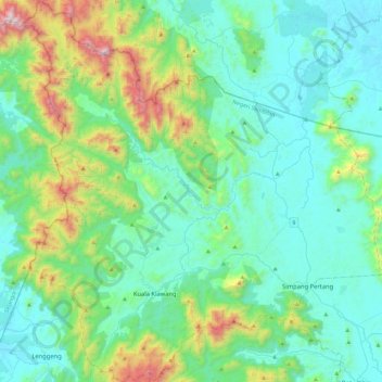
Name: Jelebu topographic map, elevation, terrain.
Location: Jelebu, Negeri Sembilan, Malaysia (2.82976 101.91385 3.29033 102.35321)
Average elevation: 307 m
Minimum elevation: 35 m
Maximum elevation: 1,435 m
Make a donation
Other topographic maps
Click on a map to view its topography, its elevation and its terrain.
Make a donation
Make a donation
Make a donation
Make a donation
Gunung Datuk
The main highlight of the mountain is a tor that consists of massive granite boulders, at the elevation of 855 m (2,805 ft).
Average elevation: 450 m
Make a donation
Gunung Datuk
The main highlight of the mountain is a tor that consists of massive granite boulders, at the elevation of 855 m (2,805 ft).
Average elevation: 455 m
Make a donation
Make a donation
Make a donation
Make a donation
Make a donation
Gunung Datuk
The main highlight of the mountain is a tor that consists of massive granite boulders, at the elevation of 855 m (2,805 ft).
Average elevation: 450 m
Make a donation
Make a donation
Gunung Angsi
Part of the Titiwangsa Mountains, it is the seventh tallest mountain in the state, behind Mts. Besar Hantu, Hantu Kecil, Telapak Buruk, Berembun and Datuk, with an elevation of 2,707 feet (825 m).
Average elevation: 552 m
Make a donation
Gunung Angsi
Part of the Titiwangsa Mountains, it is the seventh tallest mountain in the state, behind Mts. Besar Hantu, Hantu Kecil, Telapak Buruk, Berembun and Datuk, with an elevation of 2,707 feet (825 m).
Average elevation: 552 m
Make a donation
Make a donation
Make a donation
Make a donation
Make a donation
Make a donation
Pokok Kelat Gelam
Malaysia > Negeri Sembilan > Kampung Peradong > Kampung Seri Temoi
Average elevation: 206 m
Make a donation
Perkampungan Budaya Terachi
Malaysia > Negeri Sembilan > Kampung Ayer Hitam > Kampung Parit Istana
Average elevation: 128 m
Make a donation
Gunung Besar Hantu
Due to its higher altitude relative to other Negri mountains, the summit of Besar Hantu experiences a constant cool highland climate, where it also hosts a mossy forest nearby.
Average elevation: 1,015 m
Make a donation
Make a donation
Make a donation
Make a donation