
Thank you for supporting this site ❤️
Make a donation
Make a donation
Kwami topographic map
Click on the map to display elevation.
Thank you for supporting this site ❤️
Make a donation
Make a donation
About this map
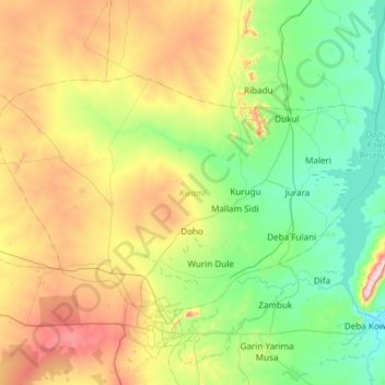
Name: Kwami topographic map, elevation, terrain.
Location: Kwami, Gombe State, Nigeria (10.31245 10.92310 10.67226 11.52187)
Average elevation: 421 m
Minimum elevation: 216 m
Maximum elevation: 885 m
Thank you for supporting this site ❤️
Make a donation
Make a donation
Other topographic maps
Click on a map to view its topography, its elevation and its terrain.