
Make a donation
Town of Fremont topographic map
Click on the map to display elevation.
Make a donation
Town of Fremont
The climate of the town is typical of the interior northeast. Made up of hills of about 2,000 ft. in elevation and valleys under 1,000 ft. The majority of the town is forested with open fields scattered about.
Make a donation
About this map
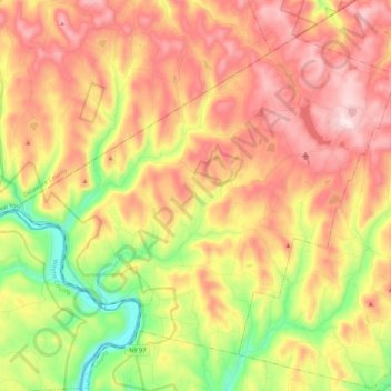
Name: Town of Fremont topographic map, elevation, terrain.
Location: Town of Fremont, Sullivan County, New York, United States (41.79325 -75.14544 41.92400 -74.92923)
Average elevation: 484 m
Minimum elevation: 220 m
Maximum elevation: 721 m
Make a donation
Other topographic maps
Click on a map to view its topography, its elevation and its terrain.
Make a donation
Make a donation
Shawangunk Ridge
United States > New York > Sullivan County
The ridge is widest (7.5 miles (12.1 km)) near the northern end and narrow in the middle (1.25 miles (2.01 km)), with a maximum elevation of 2,289 feet (698 m) near Lake Maratanza. The ridge rises above a broad, high plain which stretches to the Hudson River to the east. On the west the low foothills of the…
Average elevation: 256 m
Make a donation
Evens Lake
United States > New York > Sullivan County > Town of Fallsburg > Loch Sheldrake
Average elevation: 443 m
Make a donation
Parkston
United States > New York > Sullivan County > Town of Rockland > Parkston
Average elevation: 567 m
White Sulphur Springs
United States > New York > Sullivan County > Town of Liberty > White Sulphur Springs
Average elevation: 455 m
Make a donation