
Hosanagara taluk topographic map
Interactive map
Click on the map to display elevation.
About this map
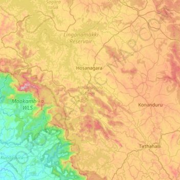
Name: Hosanagara taluk topographic map, elevation, terrain.
Location: Hosanagara taluk, Shimoga district, Karnataka, India (13.60481 74.84079 14.09681 75.37541)
Average elevation: 544 m
Minimum elevation: 5 m
Maximum elevation: 1,315 m
Other topographic maps
Click on a map to view its topography, its elevation and its terrain.
Kalaburagi
India > Karnataka > Kalaburagi taluku > Kalaburagi
The entire district is on the Deccan Plateau, and the elevation ranges from 300 to 750 m above MSL. Two main rivers, the Krishna and Bhima, flow through the district. The predominant soil type is black soil. The district has many tanks, which irrigate the land along with the river. The Upper Krishna Project is…
Average elevation: 465 m
Kodagu
Kodagu is located on the eastern slopes of the Western Ghats. It has a geographical area of 4,102 km2 (1,584 sq mi). The district is bordered by Dakshina Kannada district to the northwest, Hassan district to the north, Mysore district to the east, Kasaragod district in west and Kannur district of Kerala to the…
Average elevation: 561 m