
Santpedor topographic map
Interactive map
Click on the map to display elevation.
About this map
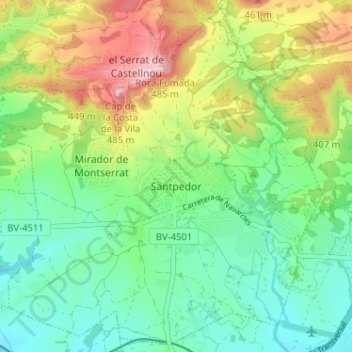
Name: Santpedor topographic map, elevation, terrain.
Location: Santpedor, Bages, Barcelona, Cataluña, 08251, España (41.76319 1.80118 41.80903 1.86537)
Average elevation: 337 m
Minimum elevation: 258 m
Maximum elevation: 486 m
Other topographic maps
Click on a map to view its topography, its elevation and its terrain.
Sant Vicenç de Castellet
Sant Vicenç de Castellet, Bages, Barcelona, Cataluña, España
Average elevation: 303 m