
Make a donation
Sylhet Division topographic map
Click on the map to display elevation.
Make a donation
Sylhet Division
The region is considered one of the most picturesque and archaeologically rich regions in South Asia. It is home to three national parks; the Lawachara National Park, Khadim Nagar National Park and Satchari National Park, as well as numerous smaller parks and forests such as the Ratargul Swamp Forest, Rema-Kalenga Wildlife Sanctuary. Its burgeoning economy has contributed to the regional attractions of landscapes filled with fragrant orange and pineapple gardens as well as tea plantations. The region has a tropical monsoon climate (Köppen Am) bordering on a humid subtropical climate (Cwa) at higher elevations. The rainy season from April to October is hot and humid with very heavy showers and thunderstorms almost every day, whilst the short dry season from November to February is very warm and fairly clear. Nearly 80% of the annual average rainfall of 4,200 millimetres (170 in) occurs between May and September.
Make a donation
About this map
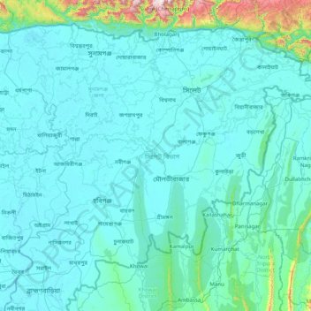
Name: Sylhet Division topographic map, elevation, terrain.
Location: Sylhet Division, Bangladesh (23.97438 90.91236 25.20735 92.49944)
Average elevation: 88 m
Minimum elevation: 0 m
Maximum elevation: 1,620 m
Make a donation
Other topographic maps
Click on a map to view its topography, its elevation and its terrain.
Bangladesh
With an elevation of 1,064 m (3,491 ft), Saka Haphong (also known as Mowdok Mual) near the border with Myanmar, is claimed to be the highest peak of Bangladesh. However, it is not yet widely recognized as the highest point of the country, and most sources give the honor to Keokradong.
Average elevation: 1,488 m
Make a donation
Rajeshpur Eco-Park
Bangladesh > Chattogram Division > Cumilla Adarsha Sadar Upazila
Average elevation: 15 m