
Thank you for supporting this site ❤️
Make a donation
Make a donation
Dhaka Division topographic map
Click on the map to display elevation.
Thank you for supporting this site ❤️
Make a donation
Make a donation
About this map
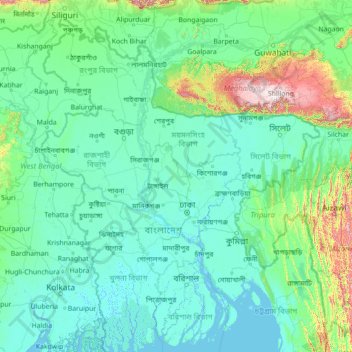
Name: Dhaka Division topographic map, elevation, terrain.
Location: Dhaka Division, Bangladesh (21.67118 87.61618 26.87118 92.81618)
Average elevation: 121 m
Minimum elevation: -2 m
Maximum elevation: 2,352 m
Thank you for supporting this site ❤️
Make a donation
Make a donation
Other topographic maps
Click on a map to view its topography, its elevation and its terrain.
Sylhet Division
The region is considered one of the most picturesque and archaeologically rich regions in South Asia. It is home to three national parks; the Lawachara National Park, Khadim Nagar National Park and Satchari National Park, as well as numerous smaller parks and forests such as the Ratargul Swamp Forest,…
Average elevation: 88 m
Rajeshpur Eco-Park
Bangladesh > Chattogram Division > Cumilla Adarsha Sadar Upazila
Average elevation: 15 m
Thank you for supporting this site ❤️
Make a donation
Make a donation