
Thank you for supporting this site ❤️
Make a donation
Make a donation
La Troncal topographic map
Click on the map to display elevation.
Thank you for supporting this site ❤️
Make a donation
Make a donation
About this map
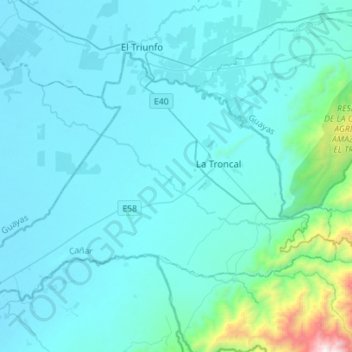
Name: La Troncal topographic map, elevation, terrain.
Location: La Troncal, Cañar, Ecuador (-2.53304 -79.52755 -2.33593 -79.24790)
Average elevation: 193 m
Minimum elevation: 18 m
Maximum elevation: 2,155 m
Thank you for supporting this site ❤️
Make a donation
Make a donation
Other topographic maps
Click on a map to view its topography, its elevation and its terrain.