
Denver County topographic map
Interactive map
Click on the map to display elevation.
About this map
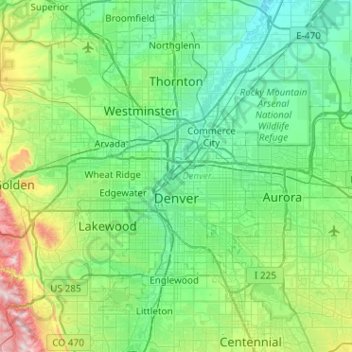
Name: Denver County topographic map, elevation, terrain.
Location: Denver County, Colorado, United States of America (39.61432 -105.10988 39.91421 -104.59969)
Average elevation: 1,673 m
Minimum elevation: 1,514 m
Maximum elevation: 2,397 m
Other topographic maps
Click on a map to view its topography, its elevation and its terrain.
Mount Wilson
United States of America > Colorado
Mount Wilson, Dolores County, Colorado, United States of America
Average elevation: 3,891 m
Eagle County
United States of America > Colorado
Eagle County, Colorado, United States of America
Average elevation: 2,769 m