
Thank you for supporting this site ❤️
Make a donation
Make a donation
Wenduine topographic map
Click on the map to display elevation.
Thank you for supporting this site ❤️
Make a donation
Make a donation
About this map
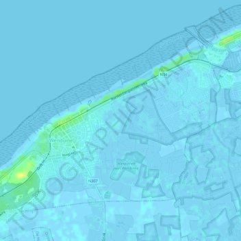
Name: Wenduine topographic map, elevation, terrain.
Location: Wenduine, De Haan, Oostende, West-Vlaanderen, België (51.28904 3.06108 51.31461 3.11530)
Average elevation: 1 m
Minimum elevation: -2 m
Maximum elevation: 17 m
Thank you for supporting this site ❤️
Make a donation
Make a donation
Other topographic maps
Click on a map to view its topography, its elevation and its terrain.
Thank you for supporting this site ❤️
Make a donation
Make a donation
Thank you for supporting this site ❤️
Make a donation
Make a donation
Thank you for supporting this site ❤️
Make a donation
Make a donation
De Meiboom
België > West-Vlaanderen > Oostende > Oudenburg > Roksem > De Meiboom
Average elevation: 6 m