
Thank you for supporting this site ❤️
Make a donation
Make a donation
Jos South topographic map
Click on the map to display elevation.
Thank you for supporting this site ❤️
Make a donation
Make a donation
About this map
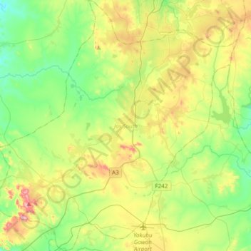
Name: Jos South topographic map, elevation, terrain.
Location: Jos South, Plateau State, 930101, Nigeria (9.61164 8.69725 9.90542 8.98188)
Average elevation: 1,243 m
Minimum elevation: 1,105 m
Maximum elevation: 1,514 m
Thank you for supporting this site ❤️
Make a donation
Make a donation
Other topographic maps
Click on a map to view its topography, its elevation and its terrain.