
Make a donation
Cranberry Lake topographic map
Click on the map to display elevation.
Make a donation
Cranberry Lake
Cranberry Lake is located at 44°13′21″N 074°50′11″W / 44.22250°N 74.83639°W / 44.22250; -74.83639 (44.2225615, -74.8362986) and its elevation is 1,489 feet (454 m).
Make a donation
About this map
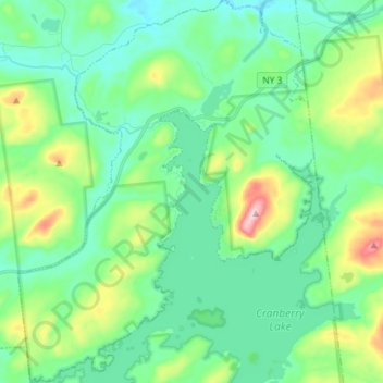
Name: Cranberry Lake topographic map, elevation, terrain.
Average elevation: 487 m
Minimum elevation: 420 m
Maximum elevation: 764 m
Make a donation
Other topographic maps
Click on a map to view its topography, its elevation and its terrain.
Catamount Mountain
United States > New York > Saint Lawrence County > Town of Colton
Average elevation: 433 m
Coney Island
United States > New York > Saint Lawrence County > Town of Pierrepont
Average elevation: 174 m
Bucks Bridge
United States > New York > Saint Lawrence County > Town of Potsdam
Average elevation: 98 m
Make a donation
Maple Mountain
United States > New York > Saint Lawrence County > Town of Fine
Average elevation: 476 m
Make a donation