Geolocate

Arizona topographic map

Interactive map

Click on the map to display elevation.

Arizona

Arizona is well known for its desert Basin and Range region in the state's southern portions, which is rich in a landscape of xerophyte plants such as the cactus. This region's topography was shaped by prehistoric volcanism, followed by the cooling-off and related subsidence. Its climate has exceptionally hot summers and mild winters. The state is less well known for its pine-covered north-central portion of the high country of the Colorado Plateau (see Arizona Mountains forests).

Wikipedia (CC-BY-SA 3.0)

About this map

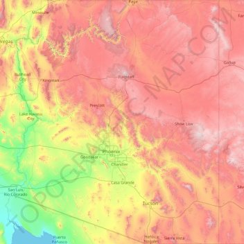
Name: Arizona topographic map, elevation, terrain.

Location: Arizona, United States (31.33221 -114.81836 37.00387 -109.04513)

Average elevation: 1,229 m

Minimum elevation: -2 m

Maximum elevation: 3,543 m

Other topographic maps

Click on a map to view its topography, its elevation and its terrain.

Mobile

United States > Alabama > Mobile County

According to the United States Census Bureau, the city has a total area of 180.1 square miles (466 km2), with 139.5 square miles (361 km2) of it being land, and 40.6 square miles (105.2 km2), or 22.5% of the total, being covered by water. The elevation in Mobile ranges from 10 feet (3 m) on Water Street in…

Average elevation: 16 m

Roswell

United States > New Mexico > Chaves County

Average elevation: 1,106 m

Granville

United States > Iowa > Sioux County

Average elevation: 441 m

Lake Tahoe

United States > California > Placer County

Lake Tahoe has a dry-summer continental climate (Dsb in the Köppen climate classification), featuring warm, dry summers and chilly winters with regular snowfall. Mean annual precipitation ranges from over 55 inches (1,400 mm) for watersheds on the west side of the basin to about 26 inches (660 mm) near the…

Average elevation: 2,077 m

Crater Lake

United States > Oregon > Klamath County

The lake is 5 by 6 miles (8.0 by 9.7 km) across, with a caldera rim ranging in elevation from 7,000 to 8,000 feet (2,100 to 2,400 m) and an average lake depth of 1,148 feet (350 m). The lake's maximum depth has been measured at 1,949 feet (594 m), which fluctuates slightly as the weather changes. On the basis…

Average elevation: 1,971 m

Barrington

United States > Rhode Island > Bristol County

Barrington lies on a low, mostly flat plain bordering the sea. This plain, composed mostly of layers of clay, gravel, sand, and silt soils, was formed by a melting glacier towards the end of the last ice age. Bedrock underlying the soil is largely composed of shales, sandstone, and conglomerate rock, with some…

Average elevation: 4 m

Florida

United States

Economic prosperity in the 1920s stimulated tourism to Florida and related development of hotels and resort communities. Combined with its sudden elevation in profile was the Florida land boom of the 1920s, which brought a brief period of intense land development. In 1925, the Seaboard Air Line broke the FEC's…

Average elevation: 6 m

Holiday

United States > Florida > Pasco County > Holiday

Average elevation: 5 m

Sarasota

United States > Florida > Sarasota County

Average elevation: 7 m

Davie

United States > Florida > Broward County

Average elevation: 6 m

Oldtown

United States > Indiana > Dearborn County > Lawrenceburg

Average elevation: 156 m

Lauderdale County

United States > Alabama

Average elevation: 210 m

Carriage Hills

United States > Alabama > Mobile County > Mobile

Average elevation: 36 m

Daphne

United States > Alabama > Baldwin County

The topography of Daphne is quite consistent from a gently sloping sea level on the west to low rolling hills further east. Generally, the entire city lies no more than 150 feet above sea level. The land along the Daphne bay coast, like other land throughout the county, is rich with sandy-loam type soils.

Average elevation: 25 m

Tillmans Corner

United States > Alabama > Mobile County

Average elevation: 39 m

Safety Harbor

United States > Florida > Pinellas County

Average elevation: 11 m

Hewett

United States > West Virginia > Boone County

Average elevation: 382 m

Park City

United States > Alabama > Baldwin County > Daphne

Average elevation: 17 m

Orange Beach

United States > Alabama > Baldwin County

Average elevation: 4 m

Buckroe Gardens

United States > Virginia > Hampton

Average elevation: 2 m

Powell

United States > Tennessee > Knox County

Average elevation: 329 m

Kitsap County

United States > Washington

Average elevation: 138 m

New York

United States > New York

The city's land has been altered substantially by human intervention, with considerable land reclamation along the waterfronts since Dutch colonial times; reclamation is most prominent in Lower Manhattan, with developments such as Battery Park City in the 1970s and 1980s. Some of the natural relief in…

Average elevation: 19 m

Jackson Oak

United States > Alabama > Baldwin County > Daphne

Average elevation: 20 m

Old Sparta

United States > Alabama > Conecuh County

Average elevation: 69 m

Bloomingdale

United States > Georgia > Chatham County

Average elevation: 8 m

Miami

United States > Florida > Miami-Dade County

Miami and its suburbs are located on a broad plain between the Everglades to the west and Biscayne Bay to the east, which extends from Lake Okeechobee southward to Florida Bay. The elevation of the area averages at around 6 ft (1.8 m) above sea level in most neighborhoods, especially near the coast. The…

Average elevation: 5 m

Salinas

United States > California > Monterey County

Prior to mass agricultural and urban development, much of the city consisted of rolling hills bisected by wooded creeks and interspersed with marsh land. Today, the city is located mostly on leveled ground, with some rolling hills and wooded gulches with creeks remaining in the north-eastern Creekbridge and…

Average elevation: 19 m

Leakesville

United States > Mississippi > Greene County

Average elevation: 31 m

Chesapeake

United States > Virginia

Average elevation: 5 m

Jacksonville

United States > Florida > Duval County

Average elevation: 10 m

Fairhope

United States > Alabama > Baldwin County

According to the United States Census Bureau, the city has a total area of 12.0 square miles (31.1 km2), of which 0.019 square mile (0.05 km2), or 0.16%, is water. Its elevation ranges from sea level at the bay to 122 feet (37 m) in the city center.

Average elevation: 17 m

Gulf Shores

United States > Alabama > Baldwin County

Average elevation: 5 m

Danielsville

United States > Georgia > Madison County

Average elevation: 219 m

Illinois

United States

Though Illinois lies entirely in the Interior Plains, it does have some minor variation in its elevation. In extreme northwestern Illinois, the Driftless Area, a region of unglaciated and therefore higher and more rugged topography, occupies a small part of the state. Southern Illinois includes the hilly areas…

Average elevation: 213 m

El Monte

United States > Alabama > Mobile County > Mobile

Average elevation: 49 m

Corpus Christi

United States > Texas > Nueces County

Average elevation: 8 m

Hawley Lake

United States > Arizona > Apache County

Average elevation: 2,538 m