
Make a donation
Chilubi District topographic map
Click on the map to display elevation.
Make a donation
About this map
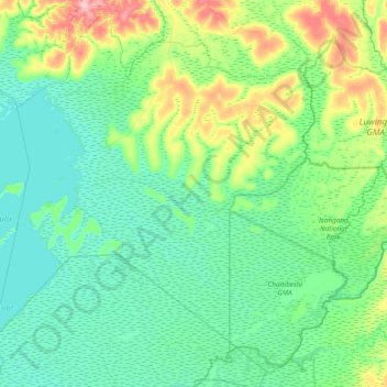
Name: Chilubi District topographic map, elevation, terrain.
Location: Chilubi District, Northern Province, Zambia (-11.50644 29.81429 -10.67419 30.72956)
Average elevation: 1,183 m
Minimum elevation: 1,161 m
Maximum elevation: 1,277 m
Make a donation
Other topographic maps
Click on a map to view its topography, its elevation and its terrain.
Mbala
The town is at the edge of the plateau covering most of Zambia, at an elevation of 1670 m, about 900 m higher than Lake Tanganyika, which comes within 22 km (straight-line distance). The escarpment above the lake is the end of the Albertine Rift, the western branch of the East Africa Rift, and the Mbala area…
Average elevation: 1,632 m
Mporokoso
Mporokoso (also spelled and pronounced 'Mpolokoso' and 'Mumpolokoso') is a town in the Northern Province of Zambia, lying at an elevation of nearly 1500 m on the flat plateau about 75 km south east of Lake Mweru Wantipa and 100 km south-west of Lake Tanganyika. It is named for Chief Mporokoso (also spelled…
Average elevation: 1,439 m
Make a donation
Mbala
The town is at the edge of the plateau covering most of Zambia, at an elevation of 1670 m, about 900 m higher than Lake Tanganyika, which comes within 22 km (straight-line distance). The escarpment above the lake is the end of the Albertine Rift, the western branch of the East Africa Rift, and the Mbala area…
Average elevation: 1,632 m