
Thank you for supporting this site ❤️
Make a donation
Make a donation
Westbere topographic map
Click on the map to display elevation.
Thank you for supporting this site ❤️
Make a donation
Make a donation
About this map
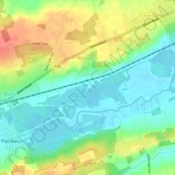
Name: Westbere topographic map, elevation, terrain.
Location: Westbere, Canterbury, Kent, England, United Kingdom (51.29633 1.12459 51.31084 1.16458)
Average elevation: 21 m
Minimum elevation: -2 m
Maximum elevation: 51 m
Thank you for supporting this site ❤️
Make a donation
Make a donation
Other topographic maps
Click on a map to view its topography, its elevation and its terrain.
Thank you for supporting this site ❤️
Make a donation
Make a donation
Thank you for supporting this site ❤️
Make a donation
Make a donation
Thank you for supporting this site ❤️
Make a donation
Make a donation
Thank you for supporting this site ❤️
Make a donation
Make a donation
Shalmsford Street
United Kingdom > England > Kent > Canterbury > Shalmsford Street
Average elevation: 54 m
Thank you for supporting this site ❤️
Make a donation
Make a donation
Reculver Country Park
United Kingdom > England > Kent > Canterbury > Hillborough
Average elevation: 10 m
Thank you for supporting this site ❤️
Make a donation
Make a donation
Thank you for supporting this site ❤️
Make a donation
Make a donation