
Thank you for supporting this site ❤️
Make a donation
Make a donation
Netarts Bay topographic map
Click on the map to display elevation.
Thank you for supporting this site ❤️
Make a donation
Make a donation
About this map
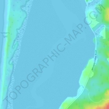
Name: Netarts Bay topographic map, elevation, terrain.
Location: Netarts Bay, Tillamook County, Oregon, United States (45.40228 -123.94573 45.40238 -123.94563)
Average elevation: 4 m
Minimum elevation: -2 m
Maximum elevation: 56 m
Thank you for supporting this site ❤️
Make a donation
Make a donation
Other topographic maps
Click on a map to view its topography, its elevation and its terrain.