Geolocate

Udenu topographic map

Click on the map to display elevation.

About this map

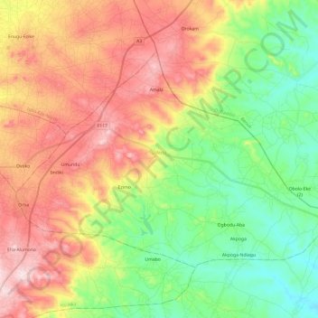
Name: Udenu topographic map, elevation, terrain.

Location: Udenu, Enugu State, Nigeria (6.80961 7.45312 6.97157 7.69228)

Average elevation: 321 m

Minimum elevation: 147 m

Maximum elevation: 550 m

Other topographic maps

Click on a map to view its topography, its elevation and its terrain.

Amala

Nigeria > Enugu State > Udenu

Average elevation: 444 m

Emene

Nigeria > Enugu State > Enugu East > Emene

Average elevation: 133 m

Udi

Nigeria > Enugu State > Udi

Average elevation: 371 m

Abor

Nigeria > Enugu State > Udi > Abor

Average elevation: 426 m

Umulokpa

Nigeria > Enugu State > Uzo-Uwani > Umulokpa

Average elevation: 45 m

Nibo

Nigeria > Enugu State > Uzo-Uwani > Nibo

Average elevation: 179 m

Ogugu

Nigeria > Enugu State > Awgu

Average elevation: 234 m